Hurricane Beryl an 'extremely dangerous' Cat 4 storm as it roars toward Caribbean
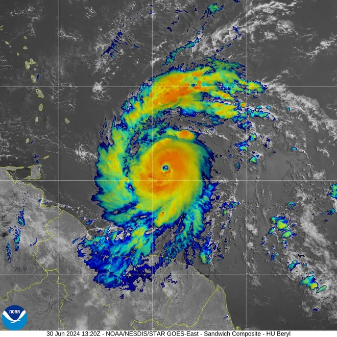
Beryl − the first hurricane of the 2024 season − intensified Sunday into a high-octane Category 4 storm packing 130-mph winds as it barreled toward the Caribbean.
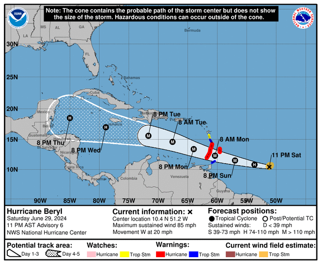
The National Hurricane Center said its reconnaissance aircraft found that Beryl, which was 310 miles east-southeast of Barbados on Sunday, is "now an extremely dangerous ... hurricane." Life-threatening winds and powerful storm surge were expected, and Beryl could delver a devastating strike on the Windward Islands early Monday, the center said.
Wind speeds on the islands could be up to 30% stronger on the tops and windward sides of hills and mountains, possibly even higher, the center said. "Catastrophic" wind damage was possible, the center said. St. Vincent and the Grenadines and Grenada were most at risk.
After Beryl's center moves across the Windward Islands early Monday, the storm will cross the southeastern and central Caribbean Sea late Monday through Wednesday.
Hurricane warnings, meaning hurricane conditions are expected in the area, were in effect Sunday for Barbados, St. Lucia, St. Vincent and the Grenadine Islands, Grenada and Tobago. A tropical storm warning was in effect for Martinique; a tropical storm watch was in effect for Dominica and Trinidad.
Beryl could bring 1 to 4 inches of rain to southeastern Puerto Rico on Monday night and into Tuesday.
Beryl is the first hurricane of what is expected to be an extraordinary 2024 season. Tropical Storm Alberto, the first named storm of the season, left at least four people dead in Mexico after it made landfall on June 20. Beryl underwent rapid intensification: It was declared a tropical depression and then a tropical storm on Friday, and by Sunday was a major hurricane.
Fueled by warm water:Hurricane Beryl, super-charged by warm seas, stuns experts

Track Beryl's path:Tropical storm Beryl expected to become first Atlantic hurricane of 2024 season
The third earliest Atlantic major hurricane on record
As Beryl continues to strengthen it's setting a number of records, according to Phil Klotzbach, a senior research scientist at Colorado State University. They include:
∎ The first June major hurricane east of the Lesser Antilles on record.
∎ The third earliest Atlantic major hurricane on record, trailing Alma on June 8, 1966, and Audrey on June 27, 1957.
∎ Beryl is now the earliest Category 4 hurricane on record. The current record was held by Hurricane Dennis which became a Category 4 on July 8, 2005.
Will Hurricane Beryl hit the US?
It's too soon to determine the path and strength of Beryl when the storm gets to the western half of the Caribbean later this week − and whether it could impact the U.S. Gulf Coast. The hurricane center expects Beryl to remain a hurricane as it reaches Mexico's Yucatan Peninsula on Friday.
But forecasters warned U.S. residents to stay vigilant. "At this point, the most likely scenario is for the storm to move westward into Mexico; however, it is very important to note that if the high pressure across the Southeast weakens, that can allow the storm to move farther north and potentially directly impact the Gulf Coast," AccuWeather Lead Hurricane Forecaster Alex DaSilva said.
What is rapid intensification?
Rapid intensification is a process in which a storm undergoes accelerated growth: The phenomenon is typically defined to be a tropical cyclone (whether a tropical storm or hurricane) intensifying by at least 35 mph in a 24-hour period.
By 11:30 a.m. Sunday, Beryl had become a Category 4 hurricane, with winds of 130 mph. That's a gain of 95 mph in just 42.5 hours.
"Rapid intensification occurs when a tropical storm or hurricane encounters an extremely conducive environment," Colorado State University hurricane researcher Phil Klotzbach said. "Typically, this environment consists of very warm water, low vertical wind shear and high levels of midlevel moisture."
Life-threatening storm surge, flooding likely
Swells from Hurricane Beryl should begin reaching the Windward and southern Leeward Islands by late Sunday, and are likely to cause life-threatening surf and rip currents. The storm surge as the hurricane arrives on Monday may reach 6 to 9 feet above normal tide levels and bring "large, destructive waves" to the coast, the hurricane center said.
Rainfall could cause flooding, and is expected to dump 3 to 6 inches in Barbados and the Windward Islands Sunday night into Monday. Up to 10 inches are possible in isolated locations, especially in the Grenadines.
The hurricane center urged anyone living in the central and western Caribbean to monitor the storm's progression given the uncertainty of the forecast.

What are the Windward Islands?
The Windward Islands are the group of Caribbean islands in the eastern part of the Caribbean Sea. They include Dominica, St. Lucia, St. Vincent and the Grenadines and Grenada. Barbados and Trinidad and Tobago are sometimes included in the group.
They are called "windward" − which means upward from a given point − because they are more windward to arriving ships than the Leeward Islands.
What is the outlook for the 2024 hurricane season?
Federal forecasters have predicted a hurricane season unlike any other, with as many as 25 named storms possible.
It is the most storms the National Oceanic and Atmospheric Administration has ever predicted in a preseason outlook. "All the ingredients are in place for an active season," National Weather Service director Ken Graham said in May.
NOAA director Rick Spinrad said the Atlantic hurricane season is shaping up to be "extraordinary" − an 85% chance for an above-average year. "The forecast … is the highest NOAA has ever issued for the May outlook," he said.
See the path of Hurricane Beryl
Current weather advisories in the U.S.
Contributing: Dinah Voyles Pulver, Doyle Rice, Mike Snyder; USA TODAY.
Disclaimer: The copyright of this article belongs to the original author. Reposting this article is solely for the purpose of information dissemination and does not constitute any investment advice. If there is any infringement, please contact us immediately. We will make corrections or deletions as necessary. Thank you.


