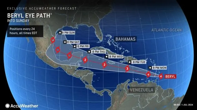
What is Hurricane Beryl's trajectory and where will it first make landfall?

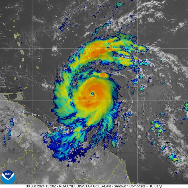
Hurricane Beryl is expected to hit the Windward Islands early Monday, according to the National Hurricane Center.
The storm, the first hurricane of the 2024 season, will bring "life-threatening" winds and storm surge to the Caribbean and become a "major" hurricane by Monday, the center said.
The storm became a hurricane on Saturday and a Category 4 storm late Sunday morning with 130-mph winds, according to the National Hurricane Center.
'Life-threatening':Hurricane Beryl a 'very dangerous' Category 3 storm as it roars toward Caribbean
Where are the Windward Islands?
The Windward Islands are 603 miles north of Venezuela, a country in northern South America.
According to Britannica, the islands north to south are:
- Dominica
- Martinique
- Saint Lucia
- Saint Vincent
- Grenada
- The Grenadines
- Trinidad and Tobago − While an extension of the South American mainland, Trinidad and Tobago are considered to constitute the southern part of the Windward Islands.
- Barbados − The island isn't part of the chain of islands, but it is usually grouped with them.
How will Beryl affect the islands?
Beryl is now forecast to arrive in the islands with a storm surge 6 to 9 feet above normal high tide levels in the onshore areas where the hurricane makes landfall. That surge will be topped with large, battering waves.
The hurricane center also bumped up the higher-end rain estimates.Most of the islands could receive 3-6 inches of rain through Monday, stated the center, but higher amounts of up to 10 inches are possible in isolated locations, especially in the Grenadines.
Hurricane Beryl Spaghetti model
Hurricane Beryl Trajectory
Tracking Hurricane Beryl
What other storms are being tracked? Texas could feel the fallout
A system the hurricane center is watching in the Bay of Campeche in the Gulf of Mexico was becoming better organized and a tropical depression could form, the hurricane center said at 2 p.m. on Sunday.
There is an 80% chance it will develop further, according to the center, but regardless of its development, the system is expected to bring rain, swells and a high risk of rip currents to the southeastern Texas coast.
It is moving northwest at 10 to 15 mph and is expected to approach Mexico's eastern coast overnight and move inland on Monday morning.
The center is also watching a third system that is east of Beryl in the tropical Atlantic.
It will likely form a tropical depression by midweek and is expected to follow a similar path to Beryl's.
The center puts the chances of a tropical storm formation over the next seven days at 70%.

Contributing: Krystal Nurse, Dinah Voyles Pulver, Susan Miller; USA TODAY
Julia is a trending reporter for USA TODAY. She has covered various topics, from local businesses and government in her hometown, Miami, to tech and pop culture. You can connect with her on LinkedIn or follow her on X, formerly Twitter, Instagram and TikTok: @juliamariegz
Disclaimer: The copyright of this article belongs to the original author. Reposting this article is solely for the purpose of information dissemination and does not constitute any investment advice. If there is any infringement, please contact us immediately. We will make corrections or deletions as necessary. Thank you.


