'Potentially catastrophic' Hurricane Beryl makes landfall as Cat 4: Live updates
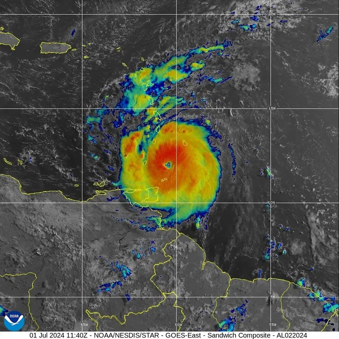
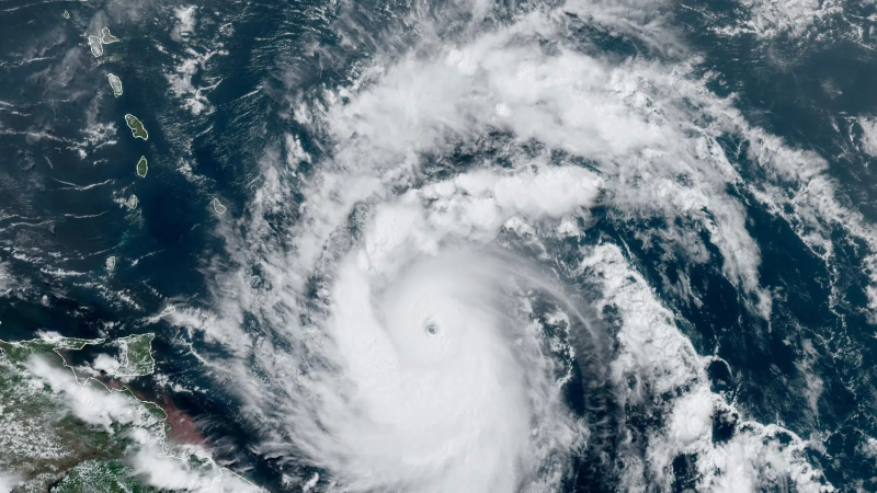
Hurricane Beryl made landfall on Grenada's Carriacou Island on Monday, roaring through the Windward Islands hours after strengthening to a fierce Category 4 storm driving devastating sustained winds of 150 mph.
Beryl is expected to remain an "extremely dangerous major hurricane" as its core slams through the eastern Caribbean, National Weather Service forecaster Eric Blake said. Some weakening is expected in the central Caribbean by midweek, but Beryl is forecast to remain a hurricane.
"Potentially catastrophic wind damage is expected where the core of Beryl moves through portions of the Windward Islands," Blake warned.
The weather service advisory warned residents in the Grenadine Islands and Grenada's Carriacou Island not to leave their shelter as winds will rapidly increase.
"This is an extremely dangerous and life-threatening situation. Take action now to protect your life!" the advisory warned. "Remain in place through the passage of these life-threatening conditions and do not venture out in the eye of the storm."
Beryl could become the strongest system to ever cross Grenada and portions of St. Vincent and the Grenadines, AccuWeather says.
The historic Beryl reached tropical storm status Friday before becoming a major hurricane Sunday as it raced toward the Caribbean with winds of 130 mph − a gain of 95 mph in just 42.5 hours. Record-warm ocean temperatures led to rapid intensification, a phenomenon that occurs when a storm strengthens by at least 35 mph in a 24-hour period.
The storm became the earliest Category 4 hurricane on record and the first June major hurricane east of the Lesser Antilles on record. Beryl hit Category 4 status Sunday, but its winds decreased slightly overnight, making it a Category 3 storm Monday. It strengthened again early Monday.
Hurricane Beryl storm tracker:See latest details, projected path of Category 3 storm
Developments:
∎ Storm surge in the Windward Islands could reach 6 to 9 feet above normal tide levels and bring "large, destructive waves" to the coast, the National Hurricane Center said.
∎ Rainfall could cause flooding and is expected to dump 3 to 6 inches in Barbados and the Windward Islands by Monday morning. Up to 10 inches are possible in isolated locations, especially in the Grenadines.
∎ After Beryl's center moves across the Windward Islands on Monday, the storm will cross the southeastern and central Caribbean Sea late Monday through Wednesday.
How Beryl grew:Hurricane Beryl, super-charged by warm seas, stuns experts

Riding out Hurricane Beryl in St. Lucia: 'We'll just kind of wing it'
Among those hunkering down for the storm was Linda Dancer, a travel agent from Charlotte, North Carolina, who arrived in St. Lucia on Saturday for an award ceremony. Over the last two days, she's watched as staff at the Sandals Grande St. Lucian resort installed plywood over windows, laid out sandbags and removed chandeliers. Dancer, 63, plans on staying in her room as the hurricane begins lashing the island.
“It was really sunny this morning, but we have outer bands coming in so it’s getting gray and darker out now,” she told USA TODAY. “I’m not taking my eyes off the weather app.”
While stocking her fridge at a Sandals resort on the west side of the island, Dancer has also been coordinating with clients whose vacations and honeymoons have been interrupted by the hurricane.
“Some of them … they're scared but you can’t leave at this point,” she said. “Some are like, ‘It's not that big a deal, we'll just kind of wing it.’”
− Christopher Cann
Will Hurricane Beryl hit Florida, US?
The hurricane center expects Beryl to remain a hurricane as it reaches Mexico's Yucatan Peninsula on Friday. AccuWeather hurricane experts expect the U.S. to avoid any major impact from the storm. Still, residents should not let their guard down.
"The most likely scenario is for the storm to move westward into Mexico," AccuWeather Lead Hurricane Forecaster Alex DaSilva said. "However, it is very important to note that if the high pressure across the Southeast weakens, that can allow the storm to move farther north and potentially directly impact the Gulf Coast."
Beryl on the move:Hurricane Beryl an 'extremely dangerous' Cat 4 storm as it roars toward Caribbean
Grenada braces for Hurricane Beryl
Dr, Terence Walters, the national disaster coordinator for Grenada, urged residents to gather documents and put them and other necessities in plastic bags. Walters, speaking at a briefing early Monday, warned residents not to go outside but said Beryl could damage or destroy some homes. Even if a house suffers damage, residents might be safer hiding in a bathroom rather than making a run for a government shelter, Walters said. About 3,000 people were in shelters awaiting the storm, he said.
"If your house is damaged or destroyed, you have to use good judgment before you make a decision to get to safety," he said.

Barbados weather worsens: 'Do not go anywhere'
In Barbados, about 160 miles northeast of Carriacou Island − Home Affairs and Information Minister Wilfred Abrahams urged residents to stay indoors with a warning “do not go anywhere until the all clear is given." Abrahams said some power lines were down and some of the island's 280,000 people were in the dark. More than 35,000 homes and businesses − about a quarter of Barbados Light & Power customers − were without power, the company said.
The worst of the storm has passed, but more damage was expected, Abrahams said. A "drone team" was ready to survey the island and help determine where work crews will be sent, he said.
Abrahams said the sun was coming out and he could see from comments on social media that many people were anxious what has been going on.
“I know in the day of social media, everybody wants to be first to get something out," he told Barbados Today. "You want to be the first to have a video. You want to be the first to show something, you want to be first to show house damage. Don’t do that in a way that might cost you your life."

What is rapid intensification?
Rapid intensification is a process in which a storm undergoes accelerated growth: The phenomenon is typically defined to be a tropical cyclone (whether a tropical storm or hurricane) intensifying by at least 35 mph in a 24-hour period.
"Rapid intensification occurs when a tropical storm or hurricane encounters an extremely conducive environment," Colorado State University hurricane researcher Phil Klotzbach said. "Typically, this environment consists of very warm water, low vertical wind shear and high levels of midlevel moisture."
What are the Windward Islands?
The Windward Islands are the group of Caribbean islands in the eastern part of the Caribbean Sea. They include Dominica, St. Lucia, St. Vincent and the Grenadines and Grenada. Barbados and Trinidad and Tobago are sometimes included in the group.
They are called "windward" − which means upward from a given point − because they are more windward to arriving ships than the Leeward Islands.
Downgraded Tropical Storm Chris still a threat in Mexico
Tropical Storm Chris, the third named storm of the season, eased to tropical depression status after crashing across the Mexican coastline near Veracruz overnight. The storm is forecast to produce rainfall totals of 4 to 8 inches across parts of eastern Mexico through Monday morning, with maximum rainfall totals around 12 inches in higher terrain of the Mexican states of Guanajuato, Queretaro and San Luis Potosi.
"This rainfall will result in areas of flooding, with mudslides possible in areas of higher terrain," the National Weather Service warned.
What is the 2024 hurricane season forecast?
Federal forecasters have predicted a hurricane season unlike any other, with as many as 25 named storms possible.
It is the most storms the National Oceanic and Atmospheric Administration has ever predicted in a preseason outlook. "All the ingredients are in place for an active season," National Weather Service director Ken Graham said in May.
NOAA director Rick Spinrad said the Atlantic hurricane season is shaping up to be "extraordinary" − an 85% chance for an above-average year. "The forecast … is the highest NOAA has ever issued for the May outlook," he said.
Hurricane Beryl Spaghetti models
Hurricane Beryl Trajectory
Contributing: Dinah Voyles Pulver, Doyle Rice, USA TODAY
Disclaimer: The copyright of this article belongs to the original author. Reposting this article is solely for the purpose of information dissemination and does not constitute any investment advice. If there is any infringement, please contact us immediately. We will make corrections or deletions as necessary. Thank you.


