Tropical Storm Ernesto on path to become a hurricane by early Wednesday
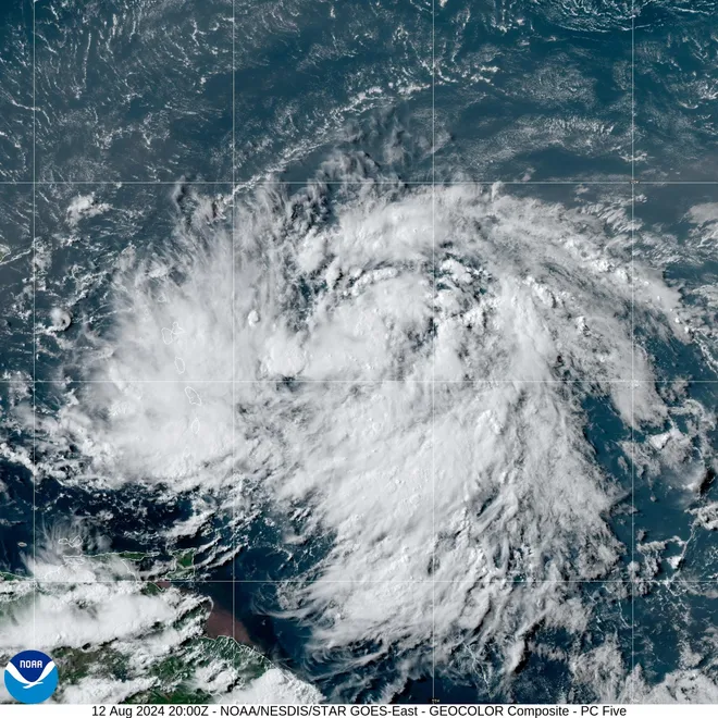
Tropical Storm Ernesto unloaded heavy rain over the northeast Caribbean islands and continued strengthening on Tuesday as authorities in Puerto Rico and the Virgin Islands prepared for the storm's arrival and possible hurricane conditions.
Ernesto developed into a tropical storm Monday night as it sped toward the northern Leeward Islands before passing near Guadeloupe and Montserrat early Tuesday.
"Additional strengthening is forecast, and Ernesto is expected to become a hurricane by early Wednesday,'' the National Hurricane Center said.
As of 2 p.m. ET, Ernesto was located 85 miles east of St. Croix and 175 miles east-southeast of San Juan, Puerto Rico, just "a few hours" away from unleashing tropical storm conditions on the Virgin Islands, according to the National Hurricane Center.
The storm strengthened and organized through the morning hours, bringing sustained winds of up to 60 mph as it barreled toward the Virgin Islands and Puerto Rico at 18 mph. Forecasters say the storm could dump up to half a foot of rain across portions of the islands by the time it pushes past Puerto Rico and into the warm western Atlantic later this week.
On Monday night, Puerto Rico Gov. Pedro Pierluisi announced the cancellation of the first day of class in public schools, the activation of the National Guard and the opening of hundreds of shelters across the island. He told residents and tourists that even though the storm is not expected to become a hurricane until after it passes Puerto Rico, it will still bring heavy rains that, in some areas, could total up to 10 inches.
The government of the U.S. Virgin Islands also announced the closure of all schools on Tuesday, and Gov. Albert Bryan Jr. urged residents at a news conference to take the storm seriously.
Tropical Storm Ernesto:Track where the storm is heading in the latest models

Experts see signs that Ernesto is developing an inner core
Forecasters spotted indications that an inner core was developing as Ernesto reached the warm waters of the Caribbean Sea on Tuesday, leading the National Hurricane Center to warn "Ernesto could be near or at hurricane strength in about 24 hours when the center is north of Puerto Rico."
As a result of Ernesto's development, the U.S. and British Virgin Islands as well as Culebra and Vieques − islands that are part of Puerto Rico − were placed under hurricane watches. “If you're in those areas, you need to go ahead and get prepared for a potential for hurricane conditions,” NHC Deputy Director Jamie Rhome said during a livestream.
Tropical storm warnings urging people to stay aware of "considerable flooding" and possible mudslides were also active across the region, including Puerto Rico, the U.S. and British Virgin Islands, St. Kitts, Nevis, Montserrat, Antigua, Barbuda, Guadeloupe, St. Martin, St. Barthelemy, Vieques and Culebra, according to the National Hurricane Center.
Sign up to get updates about current storms and weather events by location.
Increasing flight cancellations at Puerto Rico's top airport
The approaching storm is scrambling air traffic in and out of Puerto Rico, a U.S. commonwealth that's home to more than 3 million American citizens and a popular vacation destination.
Luis Munoz Marin International Airport in San Juan, the island's top flight destination, has cancelled 28 departing and 29 arriving flights Tuesday, the largest number of any airport in the world, according to the tracking website FlightAware.
For perspective, there have been 97 flight cancellations in and out of the U.S. so far Tuesday.
Where is Tropical Storm Ernesto heading?
Ernesto is expected to move over or near the Virgin Islands and Puerto Rico beginning Tuesday evening and continuing into Wednesday.
"Heavy rainfall may result in locally considerable flash flooding and mudslides in areas of the Leeward Islands through today, and over the Virgin Islands into Puerto Rico by later today through Wednesday," the hurricane center said.
Later in the week, forecasters have Ernesto shifting north and churning toward Bermuda. The warm Atlantic waters are expected to further fuel the storm as it moves north of the Greater Antilles. The NHC says Ernesto could become a major hurricane with wind speeds of 111 mph by Friday.
Will Tropical Storm Ernesto impact the US?
While the continental U.S. will largely be spared from the storm's heavy rain and winds, authorities have warned of dangerous rip currents and rough surf along the nation's Atlantic coast. Last year, all eight deaths directly tied to Hurricane Idalia were the result of large waves and rip currents.
The Coast Guard on Monday cautioned recreational boaters, fishermen, beachgoers and water sports enthusiasts in the U.S. Virgin Islands and Puerto Rico to stay out of the water "due to deteriorating sea state conditions and dangerous rip currents associated with Tropical Storm Ernesto."
“We urge the public and the maritime community to stay safe and not underestimate the impacts of this storm,” Capt. Luis Rodriguez, Coast Guard sector San Juan commander, said in a statement.
Start your morning informed: Sign up for USA TODAY's Daily Briefing newsletter.
Why isn't Ernesto forecast to hit the US mainland?
Ernesto is not forecast to hit the U.S. mainland and is instead predicted to curve out to sea. This isn't unusual: Of all the tropical storms and hurricanes that form in the tropical Atlantic in a given year, only about three on average make their way to U.S. shores, according to the textbook Meteorology Today.
Because hurricanes don't move themselves, they are steered around by large weather systems and global winds. Most often storms are pushed northward around or along the western portion of a ridge of high pressure over the Atlantic, commonly known as a Bermuda High. If the high is located to the east, then hurricanes generally slide around the high’s western edge into the open Atlantic Ocean without making landfall, according to the University of Rhode Island. That's what's predicted to happen with Ernesto later this week, the National Hurricane Center said.
Sometimes, however, the high is located to the west and extends far enough to the south, in which case storms are blocked from curving north and forced to continue west, putting a large bulls-eye on Florida, Cuba, and the Gulf of Mexico.

Tropical Storm Ernesto forms during active hurricane season
If Ernesto strengthens into a Category 1 storm, it will be the third hurricane to emerge so far this hurricane season, one experts project will be above average because of record warm ocean waters.
Across the eastern U.S., residents and authorities are still recovering from former hurricane Debby, a deadly storm that triggered dangerous floods from Florida to western New York and Pennsylvania. Last month, Hurricane Beryl – the earliest Category 5 Atlantic hurricane on record – was linked to over 20 deaths across Texas and the Caribbean.
Contributing: Doyle Rice, Dinah Voyles Pulver, USA TODAY
Disclaimer: The copyright of this article belongs to the original author. Reposting this article is solely for the purpose of information dissemination and does not constitute any investment advice. If there is any infringement, please contact us immediately. We will make corrections or deletions as necessary. Thank you.


