Hurricane Ernesto is hundreds of miles from US. Here's why East Coast is still in peril.
Churning hundreds of miles from the continental U.S., Hurricane Ernesto has kept the nation's Atlantic coastline treacherous for several days as its expansive rip currents threaten to drag beachgoers out to sea – a hazard experts say is not that unusual.
"Several storms this time of year cause rip currents" from Florida to Maine, Alex DaSilva, AccuWeather's lead hurricane expert, told USA TODAY. "The East Coast kind of sticks out and is vulnerable when there's a strong storm in the Atlantic."
Darin Figurskey, the Ocean Prediction Center's forecast branch chief, said the entire eastern coast of the U.S. becoming dangerous because of a faraway storm occurs "at least a couple times in the summer and a handful of times in the winter time."
The hazard is most troublesome in the summer, when hurricanes are most frequent and people are flocking to the beach. "It can be a beautiful, sunny day – and sometimes the waves aren't even that bad – and rip currents can be strong enough to pull people out to sea," DaSilva said.
Officials blamed Ernesto's rip currents for the deaths of at least three people in the Carolinas over the weekend. Dozens of others were rescued from rip currents while at least one home collapsed and was swallowed up by the large waves.
The storm, now approaching Canada's Newfoundland before heading toward the United Kingdom, was still triggering coastal warnings from Florida to Maine on Monday, though conditions were expected to abate by Wednesday.

Rip currents are a deadly hazard from distant storms
In the U.S., more than a dozen high surf and rip current deaths over the last five years have been caused by hurricanes passing well off the East Coast, according to Weather.com meteorologist Jonathan Belles.
Deadly storms in recent years include Lee in 2023, Teddy and Paulette in 2020, and the deadliest of all, 2019's Lorenzo. "In 2019, Hurricane Lorenzo caused eight people to lose their lives from Rhode Island to Florida in high surf and rip currents, despite it passing nearly 2,000 miles away," Belles said in an online forecast report.
And back in 2008, despite the fact that Hurricane Bertha was more than 1,000 miles offshore, the storm caused rip currents that killed three people along the New Jersey coast and required 1,500 lifeguard rescues in Ocean City, Maryland, over a one-week period.
Rip current deaths from hurricanes are increasing: A report published by the American Meteorological Society in 2023 concluded the percentage of direct deaths attributed to tropical-cyclone-related rip currents has doubled in recent years.
Where is Hurricane Ernesto?
Ernesto, which strengthened back into a hurricane on Sunday after lashing Bermuda, was located 375 miles east of Halifax, Nova Scotia, and 250 miles southwest of Cape Race, Newfoundland, on Monday evening, according to the National Hurricane Center's 5 p.m. ET update.
The Category 1 storm has sustained wind speeds of 90 mph and is racing northeast at 26 mph. The hurricane center projects the storm will weaken to an extratropical storm by early Tuesday.
Ernesto is forecast to swipe Newfoundland on Monday night and Tuesday before moving quickly across the Atlantic and hitting the British Isles by Wednesday night, according to the hurricane center and AccuWeather.
Forecasters eye system developing in the Pacific
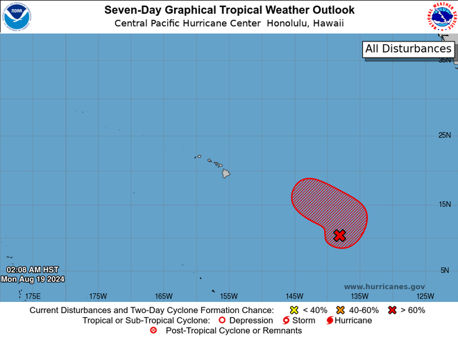
While Ernesto continues to spin across the Atlantic, forecasters at the National Hurricane Center are also keeping watch on developing systems in the Pacific Ocean, including one that has folks in Hawaii paying close attention to the forecast.
"An area of low pressure located well east-southeast of Hawaii continues to show signs of becoming better organized," the hurricane center said. "Environmental conditions are expected to be conducive for additional development and a tropical depression is likely to form during the next couple of days."
The disturbance is forecast to meander slowly northward during the next few days before accelerating into the Central Pacific basin by the latter portion of the week. Long-range weather models are showing a "higher chance for development" southeast of Hawaii this week, Hawaii News Now said.
"There is still a lot of uncertainty to which path it will take. Many models suggest that it will stay to our south, but Hawaii Island will see the most impacts," Hawaii News Now said.
Just one year ago, strong winds from distant Hurricane Dora were a factor in fanning catastrophic wildfires on Maui, killing over 100 people.

Bermuda, Puerto Rico, Virgin Islands continue recovering after Ernesto
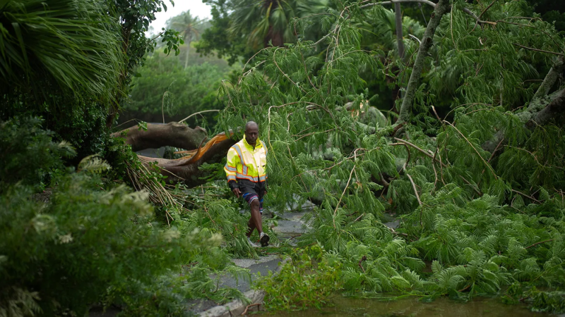
While Ernesto threatens parts of North America and the British Isles, officials, residents and tourists across Bermuda, Puerto Rico and the Virgin Islands are recovering from the storm that had caused flooding and power outages across the territories.
Last week, Ernesto pummeled Puerto Rico, causing widespread flooding and knocking out power to the majority of its residents. As of Monday morning, 51,000 homes and businesses were without power, down from a peak of over 730,000 utility customers with reported outages last week.
Meanwhile, public schools throughout Puerto Rico held their first day of school after a one-week delay because of the storm. Similarly, the Virgin Islands opened schools on Monday.
In Bermuda, officials expressed relief that the storm’s impacts were lighter than expected.
“I'm happy to report that there have been no calls for service for any major incidents or damage to any property," risk management official Lyndon Raynor said in a Saturday update.
Southeastern Newfoundland faces rip currents, heavy rain, winds
Ernesto's most dangerous conditions remain the surf and rip currents, though it will bring rain, heavy winds and big waves to southeastern Newfoundland as early as Monday night.
"Large breaking waves could bring the possibility of coastal flooding, particularly along southwest-facing shorelines from Burin east to Avalon regions," the hurricane center said.
AccuWeather forecasters said the southeast corner of Newfoundland, including St. John's, could see wind gusts of 40-60 mph while Cape Race could receive gusts as high as 100 mph. About 1-4 inches of rain is forecast to fall across the province, and local maximum amounts of 8 inches are possible, according to AccuWeather.
Ernesto to approach the UK after hitting southeastern Newfoundland
After striking southeastern Newfoundland, Ernesto is expected to race across the Atlantic and bring "significant rain and wind" to the British Isles by Wednesday, according to AccuWeather.
Though Ernesto is forecast to weaken, it will be a formidable tropical wind and rain storm when it begins pushing north of London, mostly impacting cities including Dublin and Glasgow.
AccuWeather forecasters said depending on how much of the storm survives the trek across the United Kingdom, parts of northwestern Europe could see stormy conditions late this week.
"As tropical storms and hurricanes transition to wind and rainstorms, they can still pack a wallop with flooding rain and damaging winds for many days," AccuWeather said. "In some cases, they can even produce tornadoes."
Contributing: John Bacon and Jorge L. Ortiz, USA TODAY
Disclaimer: The copyright of this article belongs to the original author. Reposting this article is solely for the purpose of information dissemination and does not constitute any investment advice. If there is any infringement, please contact us immediately. We will make corrections or deletions as necessary. Thank you.


