Hone downgraded to tropical storm as it passes Hawaii; all eyes on Hurricane Gilma
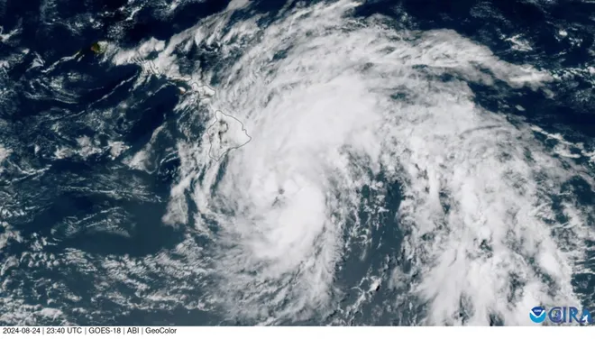
Emergency crews worked Monday to restore power and survey damage after Hurricane Hone lashed the Big Island of Hawaii while weather forecasters tracked Hurricane Gilma in the eastern Pacific.
Hone strengthened into a Category 1 storm as it moved south of Big Island early Sunday, dumping over a foot of rain across portions of the island while some areas received 15 to 18 inches of rain. Rain inundated several major roads as waterways swelled and officials opened shelters. Thousands of homes and businesses lost power, but there were no reports of major damage.
Hone weakened into a topical storm late Sunday as it pushed to the west of the islands of Hawaii, according to the Central Pacific Hurricane Center. By Monday morning, coastal watches and warnings were discontinued while officials downgraded a flood warning across the Big Island to a flood watch.
Hurricane Gilma tracker:See latest details, projected path of storm in Pacific

On Monday morning, several beaches across Big Island were closed. Five public schools canceled classes because of power outages and dangerous road conditions, according to the Hawaii County website. Over 12,000 utility customers remained without power across the islands of Hawaii, according to PowerOutage.us. The vast majority of outages were reported throughout Big Island.
"We are moving into the recovery stage," said Hawaii County Mayor Mitch Roth in a Facebook livestream Sunday afternoon. He said emergency crews will inspect damage across the island this week as linemen restore power and authorities begin preparations for Hurricane Gilma. "Gilma is coming so ... even through we're done with this one, it's good to start preparing for the next one."

Where is Tropical Storm Hone?
Tropical Storm Hone was located 240 miles west-southwest of Honolulu and 205 miles southwest of Lihue early Monday morning, according to the Central Pacific Hurricane Center in Honolulu.
The storm had maximum sustained winds of 65 mph and its tropical force winds extended outward 80 miles from its center. Churning west at 13 mph, the storm is forecast to continue moving away from Hawaii and weaken early this week, the hurricane center said.
Hurricane Gilma forecast to swipe the islands of Hawaii
While Tropical Storm Hone continued moving away from the Big Island of Hawaii, forecasters and local officials are warning about the threat of a hurricane in the eastern Pacific.
Hurricane Gilma, over 1,200 miles east of Hilo, Hawaii, is forecast to bring impacts such as showers, thunderstorms and gusty winds to the state as early as Tuesday night or Wednesday morning, according to AccuWeather. As of early Monday, the storm had sustained winds of 105 mph, making it a Category 2 storm.
Forecasters project the storm will pass just north of the Hawaiian islands and they stressed that Gilma's impacts will depend greatly on how close it comes to the state. On its current track, Gilma is expected to lose strength and be downgraded to a tropical depression in the latter half of the week, AccuWeather said.
"The combination of both tropical cyclones will likely bring an extended period of rough seas and surf to the islands, which will pose dangers to boarders, swimmers and small craft," AccuWeather said, referring to Hone and Gilma.
"Gilma is still very far of us," Sean Miller, a meteorologist with the National Weather Service in Honolulu, said in a Facebook livestream Sunday. "There's still time to watch it."
Back-to-back storms passing near Hawaii is extremely rare, experts say
If Hurricane Gilma lashes the islands of Hawaii by Sunday, it will be the first time in over 30 years that two named storms passed within 300 miles of the state within a week.
The last time back-to-back named storms hit the islands was in September 1992 when Hurricane Iniki, the most powerful storm to directly hit Hawaii, was followed three days later by tropical depression Orlene, according to AccuWeather.
Storm systems don't need to barrel directly over Hawaii to wreak havoc. Last year, Hurricane Dora fanned the deadliest wildfires in the U.S. in over a century.
Forecasters had worried Tropical Storm Hone's winds could replicate Dora's impact, especially as swaths of the islands suffer relentless drought conditions, but the storm brought enough rain to quell fears and canceled wildfire warnings for portions of Hawaii's Big Island.
Tropical Storm Hector expected to strengthen in the eastern Pacific
To the east of Hurricane Gilma is Tropical Storm Hector, the latest storm to break out in the Pacific.
The storm is expected to continue tracking west in the general direction of Hawaii over the next few days, according to the National Hurricane Center. While officials are closely tracking the storm, it's far too early to tell how close it will come to the state.
As of late Sunday, Hector was over 1,000 miles west-southwest of Mexico's Baja peninsula. The storm was moving west at 10 mph with maximum sustained winds of 50 mph, the hurricane center said.
As wind shear decreases, the storm will likely gain strength as it moves toward the central Pacific basin early this week. Hector's intensification is expected to be limited by a region of dry air and stronger wind shear, according to the hurricane center.
Contributing: Jorge L. Ortiz, USA TODAY
Disclaimer: The copyright of this article belongs to the original author. Reposting this article is solely for the purpose of information dissemination and does not constitute any investment advice. If there is any infringement, please contact us immediately. We will make corrections or deletions as necessary. Thank you.
