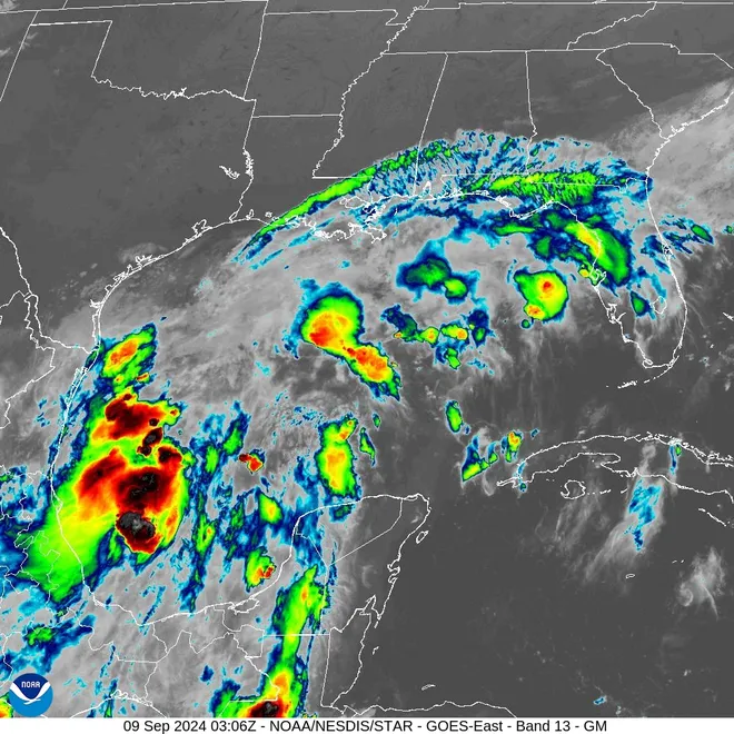
Tropical Storm Francine forms in Gulf, headed toward US landfall as a hurricane
Tropical Storm Francine formed in the Gulf of Mexico on Monday and could be a low-end Category 1 hurricane by Wednesday, one headed toward a landfall on the Upper Texas or southwestern Louisiana coasts.
A hurricane watch was issued for portions of the Louisiana coast, meaning hurricane conditions are possible there within the next 48 hours.
A tropical storm watch was issued earlier for Southern Texas, from Port Mansfield south to the Rio Grande River, which means tropical storm winds are possible along the coast by Tuesday evening. A tropical storm watch also is in effect southward along the Mexican coast to Barra del Tordo.
The center of the system was an estimated 245 miles south southeast of the mouth of the Rio Grande and about 480 miles south of Cameron, Louisiana, on Monday morning. With sustained winds estimated at 50 mph, Francine was barely moving at 5 mph in a north-northwesterly direction.
Francine is the sixth named storm of the season
Francine is the sixth named storm of the 2024 Atlantic hurricane season, and the first since Ernesto dissipated on Aug. 20.
The system is one of three the hurricane center is watching. Another is in the central tropical Atlantic and is given a 60% chance of becoming a tropical storm within 48 hours. A storm farther to the east has a 60% chance of development over the next week.
The center’s forecast calls for Francine to be a low-end Category 1 hurricane on Wednesday with 80-mph winds.The storm is forecast to bring 4–8 inches of rainfall to the coast. Amounts up to 12 inches are possible in some locations in northeastern Mexico and along the Texas and Louisiana coasts through Thursday, presenting a flash flood risk, the center said.
Francine is forecast to begin a faster motion to the northeast by late Tuesday as it meets a cold front along the Gulf Coast. It would be just offshore along the Texas coast moving toward a potential landfall along the upper Texas or Louisiana coast on Wednesday, said Donald Jones, a meteorologist in the National Weather Service office in Lake Charles, Louisiana in a Sunday night briefing.
Hurricane tracker: Updates on the path of every storm
Storm could possible become a Category 2
Jones urged residents in Southwestern Louisiana to keep an eye on the weather and said there was at least some chance that storm could even become a Category 2 hurricane. So far, landfall could be on Wednesday evening along the southwestern Louisiana coast, Jones said.
Water temperatures in the Gulf are warmer than normal, and could be conductive to hurricane development, Jones said. Once the system forms a well-defined center, the hurricane center said steady strengthening is possible. The storm would be over the warm Gulf in an area of abundant moisture, the hurricane center said, but could encounter an increase in wind shear and slightly drier air that could prevent significant strengthening.
"We're going to be looking at 8 to 12 inches of rainfall south of Interstate 10 in southwestern Louisiana," Jones said.
At the moment, the biggest threat is flooding, Jones said. The track of the tropical storm shifted a little eastward Sunday and could shift even farther east, he said.
Disclaimer: The copyright of this article belongs to the original author. Reposting this article is solely for the purpose of information dissemination and does not constitute any investment advice. If there is any infringement, please contact us immediately. We will make corrections or deletions as necessary. Thank you.


