Tropical storm warning issued for Carolinas as potential cyclone swirls off the coast
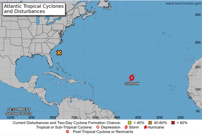
The Carolinas are under a tropical storm warning Sunday due to a low-pressure system swirling off the coast, which forecasters warned could fuel days of high winds, heavy downpours, and coastal flooding.
The potential tropical cyclone was "moving slowly" off the coast of the Carolinas with sustained winds of 45 mph, the National Hurricane Center said in its 11 p.m. Sunday advisory. The storm was located about 125 miles east-southeast of Charleston, South Carolina, and 180 miles south-southwest of Cape Lookout, North Carolina.
The hurricane center said the system "should reach the coast within the warning area" on Monday and is likely to become a tropical storm overnight or Monday morning. Some strengthening is also possible before the system makes landfall.
The National Weather Service in Wilmington, North Carolina, said flash flooding from excessive rainfall is possible through Tuesday morning. The areas most likely to be impacted are rivers, creeks, streams, and other low-lying and flood-prone locations.
Low-end tropical storm-force winds were expected Sunday night along the coast, according to the weather service. The hurricane center warned that the storm may spur a couple of tornados Monday across the eastern Carolinas.
As the potential system moves toward shore it will cross over warm waters, including the warmer than normal Gulf Stream, in an area of low wind shear, which could allow some strengthening to occur, the National Hurricane Center said.
Tropical storm warnings were issued for the coast of South Carolina and North Carolina, according to the hurricane center. The potential system is expected to bring a risk of scattered flash and urban flooding, in addition to minor river flooding across parts of the region.
The hurricane center also warned of a risk of isolated flash and urban flooding across much of the Mid-Atlantic region through Wednesday.
AccuWeather said the heavy rain is forecast to begin across parts of North Carolina, South Carolina, and Virginia as soon as Sunday night. Rain totals over the next few days will reach 4-8 inches in many areas − and could top 20 inches in some locations. Coastal flooding, rip currents, and beach erosion could stretch from northeastern Florida to the Delaware, according to AccuWeather.
Storm tracker:Tropical Storm Gordon, Francine remnants, and another storm brewing
Other developments:
∎ Elevated tides associated with the full moon, large swells, and strong northeast winds are forecast to cause high tides along the coast leading to minor or moderate coastal flooding through early in the week, the weather service said. Additional storm development could also further increase the risk of more significant coastal flooding.
∎ Ileana weakened to a tropical depression Sunday, a day after crashing onto Mexico's coast as a tropical storm near the tourist city of Cabo San Lucas. Additional weakening is forecast, and Ileana was expected to become a "remnant low" by day's end.
∎ Gordon lost ferocity out in the Atlantic and weakened to a tropical depression by 5 p.m., according to the hurricane center. Gordon posed no threat to land, the weather service said.

Gulf of Mexico energy production stalled by Francine
More than 16,000 homes and businesses remained with power in Louisiana, four days after Francine made landfall as a Category 2 hurricane. The storm, which toppled trees, flooded coastal areas, and cut power in four states, also slammed across prime offshore oil and natural gas-producing areas. Nearly a fifth of crude oil production and 28% of natural gas output in U.S. Gulf of Mexico federal waters remained offline Sunday, the U.S. offshore energy regulator said.
"Once all standard checks have been completed, production from undamaged facilities will be brought back online immediately," the Bureau of Safety and Environmental Enforcement said in a statement. "Facilities sustaining damage may take longer to bring back online."
Carolina storm could make landfall Monday
The menacing weather front near the Carolinas could reach tropical storm status in the next couple of days, driving some gusts of up to 80 mph and prompting power outages, Accuweather warned, adding that landfall was most likely along the North Carolina coast near the South Carolina border late Monday.
"Some access roads to the barrier islands may be blocked by high water or damaged by erosion," said AccuWeather senior meteorologist Alex Sosnowski. "Beachfront homes may be at risk."

Risk for swimmers on Outer Banks of North Carolina
The Outer Banks of North Carolina are known for currents that can be dangerous for swimmers. The new system heightened the risk, the weather service said in an update Sunday. The good news: The most likely time for strong rip currents to occur Sunday was a couple hours either side of low tide, which took place before noon. Still, the risk of rip currents remained, and the update warned inexperienced swimmers to stay out of the water.
"Rip currents can sweep even the best swimmers away from shore into deeper water," the update warned. "Dangerous shore break can throw a swimmer or surfer head first into the bottom causing neck and back injuries."
'Homegrown' storm makes short trip to shore
The storm would reach tropical depression status if a center is defined and winds gain circular motion. Tropical storm status would be reached and the storm would be named if sustained winds reach 39 mph.
AccuWeather referred to the storm as a relatively rare "homegrown development" because most tropical systems during the hurricane season develop thousands of miles to the south over the central Atlantic and make their way west to shore.
Contributing: Dinah Voyles Pulver and Charles Ventura, USA TODAY; Sherry Jones and Madison Lipe, Wilmington StarNews; Reuters
Disclaimer: The copyright of this article belongs to the original author. Reposting this article is solely for the purpose of information dissemination and does not constitute any investment advice. If there is any infringement, please contact us immediately. We will make corrections or deletions as necessary. Thank you.


