Tropical Storm Helene forms; Florida bracing for major hurricane hit: Live updates
Tropical Storm Helene formed over the Caribbean on Tuesday as residents across Florida prepared for a strike from what is expected to be a massive and powerful hurricane.
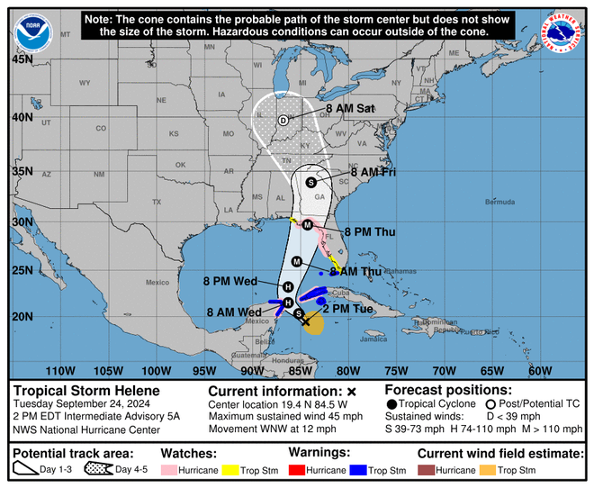
The storm is expected to dump heavy rain and trigger possible mudslides across western Cuba as it passes between the island and Mexico's Yucatan Peninsula on Tuesday night, putting it on a path toward to the Gulf Coast of Florida and the state's storm-battered Big Bend, according to the National Hurricane Center.
As it churns over the warm waters of the Gulf of Mexico, Helene is expected to rapidly intensify into a major hurricane with 115-mph winds by the time it makes landfall Thursday. Forecasters warned the storm could bring life-threatening storm surge as high as 15-feet, hazardous winds and around 10 inches of rain to parts of Florida, most of which is under a state of emergency.
Because the storm is so large and is forecast to be moving quickly as it crosses the coast, the hurricane center also warned that strong winds and torrential rain will be felt hundreds of miles inland across the Southeast after landfall, including across Georgia, the southern Appalachians and the Tennessee Valley.
“Everyone along the Florida Panhandle and Big Bend region needs to be prepared for hurricane impacts,” said AccuWeather lead hurricane expert Alex DaSilva, adding that Helen has the potential to become the strongest hurricane to make landfall in the U.S. this season.
Developments:
∎ Hurricane watches were in effect Tuesday across the Yucatan Peninsula and portions of western and central Cuba, including the Pinar del Rio Province, according to the National Hurricane Center. Further watches and warnings were expected later Tuesday.
∎ As counties and municipalities begin preparing shelters for evacuated residents, especially near low-lying and coastal areas, the state has closed at least 59 parks across Florida, according to the state parks website.
∎ If the storm makes landfall as a hurricane, it would be the fourth in the mainland U.S. this year, joining Beryl, Debby and Francine.
Track the storm:See the latest path, models
Storm-battered region of Florida prepares for Helene
Residents across the Big Bend of Florida are storm weary.
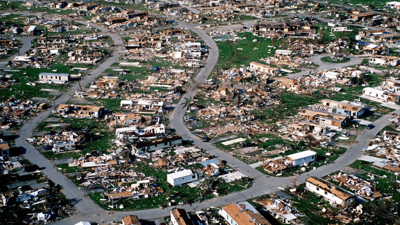
Last month the region was pummeled by Hurricane Debby’s flooding rains and tornadoes. Nearly a year earlier, Hurricane Idalia tore across the region, flattening homes and leaving entire neighborhoods underwater. The two storms, both of which made landfall in Taylor County, created about a combined $500 million in agricultural losses, according to a University of Florida analysis.
Now, as Helene churns toward the state’s Gulf Coast, residents are preparing for possibly more devastating impacts.
“We’re still suffering," Michelle Curtis told the Tallahassee Democrat, part of the USA TODAY Network. The Perry native said blue tarps from damage inflicted by the one-two punch of Idalia and Debby are still a common sight in her neighborhood.
Jeff Pittman, a fourth-generation peanut and cotton farmer whose crops were wrecked by Hurricane Michael six years ago, spent Monday preparing generators so his neighbors' cows would not go without water.
“We’re taking all precautions, everything we can think to do,” Pittman said. “It looks like it could be a very serious situation come Thursday.”
– Ana Goñi-Lessan, James Call and Jeff Burlew, the Tallahassee Democrat

Florida county issues mandatory evacuations
Franklin County, in the Florida Panhandle, issued a mandatory evacuation Tuesday for all its nearby barrier islands, citing the danger posed by Helene.
The evacuations across St. George Island, Dog Island, Bald Point and Alligator Point went into effect at noon, Franklin County Emergency Management announced on Facebook. Additional evacuations are possible.
“If you feel unsafe, then do not shelter at home; leave until the storm has passed and then return,” Franklin County Emergency Management said. “Remember that if you have health concerns, EMS will not be able to respond if wind speeds reach 40 mph sustained. It is unsafe for ambulances to be dispatched in high winds.”
Meanwhile, counties and cities across the state opened sandbag locations and prepared shelters. In Tallahassee, Florida State and Florida A&M universities announced closures through Friday.
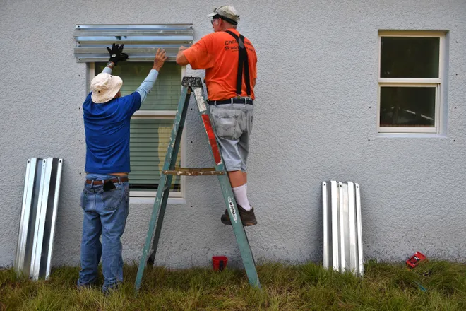
North Florida residents board up homes ahead of Helene
Instead of getting ready for the lunch rush on Tuesday, restaurant owner Stanley West and a friend lifted metal chairs onto the deck of a pontoon boat, hauling them away for safekeeping so they wouldn't turn into projectiles in hurricane-force winds.
West, who lives in Wakulla County, said he's not taking any chances with Helene, which could unleash a 15-foot storm surge along the Big Bend coast. He's packing up everything.
"Usually I leave some stuff because I'm not worried about it too much," West told the Tallahassee Democrat, part of the USA TODAY Network. "But this time around, we're going to try to get out everything that we can. It's easier to bring it back and have it than it is to lose it."
Residents throughout the northern Florida county spent Tuesday boarding up their homes, prepping their boats and making evacuation plans. Lines for gasoline stretched for blocks and grocery stores were packed with residents buying water, food and batteries.
"If we get a 15-foot surge, ain't nothing I can do but cross my fingers and pray, and I will be doing a lot of that," West said.
– Ana Goñi-Lessan, Tallahassee Democrat
Why is Helene so large?
Helene’s wind radius is forecast to be among the largest ever recorded in a storm at similar latitudes, in the 90th percentile, the hurricane center said Tuesday.
Tropical storm force winds already extend outward up to 140 miles from the center, but Jamie Rhome, the center’s deputy director, said Helene is expected to grow even larger as it reaches the Gulf of Mexico.
Its large size is a direct result of the Central American gyre, said Sam Lillo, a meteorologist and software engineer for DTN Weather. While gyre typically refers to a rotating current in water, they also occur in atmospheric winds. It’s a broad circulation of air that spins counterclockwise.
The gyre often appears in the western Caribbean at this time of year, Lillo said. When it forms a tightened circulation, it can develop into a large storm such as Helene. Previous research has shown the gyres often produce exceptional rainfall that can lead to catastrophic flooding.
When storms dance: Helene could undergo Fujiwhara effect
The Fujiwhara effect – which describes the rotation of two storms around each other – is one of meteorology's most exquisite dances. It's most common with tropical cyclones such as typhoons or hurricanes, but it also occurs in other cases.
Forecasters say soon-to-be Hurricane Helene could eventually undergo a Fujiwhara "interaction" with another storm over the central US, which the weather service refers to as a trough of low pressure.
As Helene moves across Florida into the Southeast, "models suggest it will undergo a Fujiwhara interaction with a trough of low pressure over the Ozarks," the National Weather Service in Shreveport, Louisiana, said in an online forecast discussion posted Monday.
"Essentially, this means the remnants of the landfalling hurricane will move in close proximity of the larger Ozarks trough, and then try to circulate around it before it gets absorbed, forming a larger closed trough," the weather service said.
"This phenomenon is incredibly rare at this latitude!," KATV meteorologist James Bryant posted on X.
Where is the storm now?
Helene was located in the Caribbean Sea on Tuesday afternoon, and it's forecast to bring dangerous conditions such as flooding and storm surge across the Cayman Islands, the Yucatan Peninsula and Cuba through midweek.
The storm was located 175 miles east-southeast of Cozumel, Mexico, an island off the Yucatan Peninsula, and 175 miles south of the western tip of Cuba, according to the National Hurricane Center's 2 p.m. update. The storm had maximum sustained winds of 45 mph and was moving west-northwest at 12 mph.
On its current track, the center of the system is expected to push across the northwestern Caribbean Sea on Tuesday night before emerging over the eastern Gulf of Mexico on Wednesday.
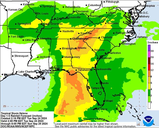
The system could dump 4 to 8 inches over western Cuba and the Cayman Islands with isolated totals around 12 inches, the hurricane center said, warning of "considerable flooding." Over the eastern Yucatan Peninsula, 4 to 6 inches of rain are expected with isolated totals over 8 inches. Other threats include storm surge and heavy wind gusts.
"Hurricane conditions are possible within the watch areas in Cuba and Mexico by early Wednesday," the weather service said. "Hurricane conditions are possible within the U.S. watch areas late Wednesday and early Thursday."

Flooding rains, storm surge forecast across Gulf Coast, Southeast
As Florida braces for the arrival of Helene, forecasters are warning the storm will produce widespread impacts stretching hundreds of miles inland from where it makes landfall.
Forecasters say the storm system could drop around 10 inches of rain across parts of northern Florida and throughout portions of the Tennessee Valley. Rainfall amounts from 4-8 inches are predicted for much of the Southeast, from southwest Florida to parts of Alabama, Georgia, the Carolinas, Tennessee and Virginia.
“This is expected to be a large hurricane with a major storm surge threat and impacts that will reach hundreds of miles inland from where this storm makes landfall,” AccuWeather chief meteorologist Jon Porter said. “We expect significant flooding problems that could reach as far inland as Atlanta and potentially a secondary area of significant flooding in the southern Appalachians.”
Life-threatening storm surge along the Gulf Coast of Florida is also a central concern. Forecasters say water levels could reach up to 10-15 feet above ground level throughout much of the Big Bend region of Florida, which is still recovering from Hurricane Debby after it lashed the area last month, and 2023's Hurricane Idalia.
Along the shore of Tampa Bay, storm surge could reach 5-8 feet above ground level, according to the hurricane center. "The potential for life-threatening storm surge and damaging hurricane-force winds along the coast of the Florida Panhandle and the Florida west Gulf Coast is increasing," the hurricane center said Tuesday morning.

Helene would be Florida's 9th major hurricane hit since 2000
The storm is forecast to become a major hurricane, a Category 3, before approaching the Florida Gulf Coast on Thursday, the hurricane center said. According to Colorado State University hurricane researcher Phil Klotzbach, eight major hurricanes have made landfall in Florida since 2000: Charley and Jeanne in 2004; Dennis and Wilma in 2005; Irma in 2017; Michael in 2018; Ian in 2022; Idalia in 2023.
Storm disrupts Gulf oil production
U.S. oil producers scrambled Monday to evacuate staff from Gulf of Mexico oil production platforms as the second hurricane in two weeks was predicted to tear through offshore oil producing fields.
Oil companies BP, Chevron and Shell have begun evacuating offshore staff, and several have paused some production.
Just two weeks ago, Hurricane Francine roared across the Gulf of Mexico, peaking as a Category 2 with 100-mph winds as it made landfall in Louisiana.
– Reuters
Florida governor urges residents to get ready for Helene
Florida Gov. Ron DeSantis on Tuesday expanded the number of counties under an emergency declaration to 61, the vast majority of the state’s 67 counties.
A day earlier, the governor signed an executive order declaring a state of emergency for 41 counties, allowing Florida to offer resources to local communities ahead of any potential storm impacts. The state also requested an emergency declaration from FEMA, which is expected to approve it quickly, DeSantis said at a news conference Tuesday.
DeSantis said the state is deploying high water vehicles and generators, as well as amassing 18,000 power linemen to respond to Helene. Additionally, 3,000 National Guard soldiers are on standby and authorities have begun to stage flood protection devices across the Gulf Coast, especially near utility substations, DeSantis said.
The governor told residents to heed emergency warnings and familiarize themselves with their evacuation zone. Residents should buy non-perishable flood, water and “prepare for your power to go out."
“Prepare, you have time to do it," DeSantis said. "There’s a lot of uncertainty with this storm, but the one thing that is certain is that we are going to see some impacts.”

Record warm 'Loop Current' could fuel Helene
Hurricanes gain power from warm water, and parts of the Gulf of Mexico are record warm.
"The ocean heat content in the Gulf is extremely high, particularly inside the Loop Current, which future-Helene will pass over," said University of Miami meteorologist Brian McNoldy this week on X. "The area-average value is obliterating previous values for the date," he said.
The Loop Current is a flow of warm water that travels through the Gulf of Mexico, past the Florida Keys, and up the Atlantic Seaboard.
Speaking about the developing storm, McNoldy cautioned Tuesday that "It's not even a tropical depression yet, but don't let that fool you!"
Start your day smart: Sign up for USA TODAY's Daily Briefing newsletter.
Hurricane watches issued across Gulf Coast of Florida
In a morning update from the National Hurricane Center, meteorologists issued a hurricane watch for the majority of the Gulf Coast of Florida, running from Englewood, just south of Sarasota, to Indian Pass in the Big Bend region. Cities including St. Petersburg and Tampa Bay are under hurricane watches.
"A hurricane watch means that hurricane conditions are possible within the watch area," according to the hurricane center. "A watch is typically issued 48 hours before the anticipated first occurrence of tropical-storm-force winds, conditions that make outside preparations difficult or dangerous."
Some areas of the state are under tropical storm watch while a storm surge watch was issued across most of the Gulf Coast, indicating that "there is a possibility of life-threatening inundation, from rising water moving inland from the coastline," during the next 48 hours, according to the weather service.
Read more:Will Hurricane Helene emerge like a monster from the Gulf?
Concerns mount over rapid intensification
The tropical system in the western Caribbean may not look like much yet, but don’t be fooled. History has shown the Gulf of Mexico can be a pressure cooker, turning systems like this one from wimpy windstorms to devastating monster storms almost overnight under the right conditions.
The storm is forecast to strengthen with potential explosive force in the Gulf. It’s called rapid intensification and it has happened before. In fact, most of the worst hurricanes in history have experienced rapid intensification, Ken Graham, the National Weather Service director, has said in interviews with USA TODAY.
Disclaimer: The copyright of this article belongs to the original author. Reposting this article is solely for the purpose of information dissemination and does not constitute any investment advice. If there is any infringement, please contact us immediately. We will make corrections or deletions as necessary. Thank you.


