Tornado threats remain in Oklahoma after 11 injured, homes damaged in weekend storms
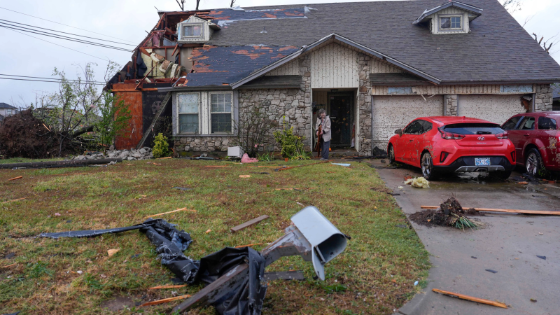
OKLAHOMA CITY – Thunderstorms and possible tornadoes remained in the forecast Monday for the south-central U.S., including Oklahoma, where a breakout of twisters over the weekend injured at least 11 people, damaged homes and left thousands without power, officials said.
Flood and tornado warnings were active throughout central and eastern Oklahoma as forecasters anticipated additional rain to inundate the storm-battered state. The flood advisories extended into Arkansas, Missouri, Kansas and Texas.
Citing the danger posed by the incoming storms, several school districts and colleges, including Oklahoma State University, canceled classes for Monday. The Oklahoma City Municipal Court postponed hearings.
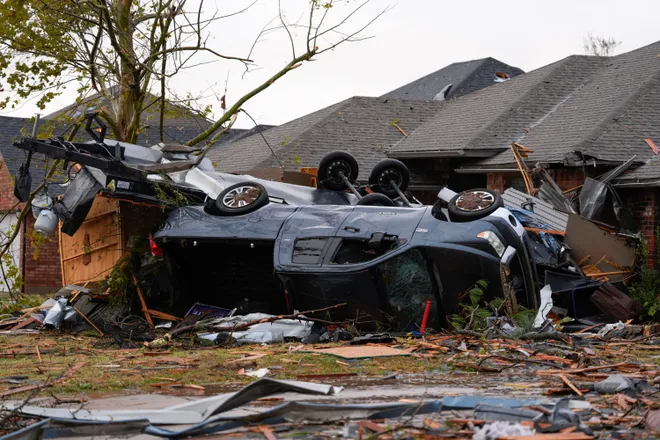
Multiple tornadoes damaged at least 100 homes as flooding trapped people in their cars and wind uprooted trees and tangled power lines. In Tulsa County, about 100 miles northeast of Oklahoma City, lightning strikes set a house aflame.
Oklahoma Gov. Kevin Stitt issued an emergency declaration for six counties impacted by the storms. He said at a news conference Sunday that among the state's main priorities will be restoring power to polling places ahead of Election Day.

The governor asked residents to monitor weather updates Monday. "Sometimes as Oklahomans, as a fourth generation Oklahoman, you think 'Man, it could never hit me,' but you've got to be really really cautious," he said.
In Oklahoma City, Krystal Kearns was in her home when a tornado siren began to blare. Her dog jumped into her bed and she heard a window shatter. After the storm passed, she was shocked by the damage.
"My gazebo is up in that tree," Kearns told the Oklahoman, part of the USA TODAY Network. The storm shredded her garden, smashed her fence and drove a piece of wood into her new roof.
“How do you have any sense of normalcy out here right now? We found part of a bumper over here. My shed is still standing," Kearns said. "I don’t know how that happened."
Power outages persist in Oklahoma, made worse by ongoing storms
Over 10,000 homes and businesses were in the dark across central and eastern Oklahoma Monday afternoon, down from the nearly 82,000 people without power Sunday morning, according to a USA TODAY outage tracker.
Oklahoma Gas and Electric Company, the state's largest power provider, said the weekend storms broke 209 power poles, 70 transformers and damaged 64 transmission structures and other equipment.
As of 11:30 a.m. Monday, 94% of OG&E customers who were without power after the weekend storms had their service restored within a 24-hour period. However, Monday's storms caused additional outages and slowed down operations as crews paused their work when rain and winds picked up, OG&E said.
Approximately 9,000 customers were without service at as of 11:30 a.m., which includes approximately 4,600 homes and businesses that lost power from Monday's storms.
Lifelong Oklahoman gives away free food to those in need
After seeing reports of heavy storm damage, Antonio Alfaro drove his food truck, La Birria SuPerb, to the affected areas around Oklahoma City on Sunday and handed out free hot dogs and hamburgers to families and first responders.
“They were completely distraught,” he said of residents whose homes were damaged. “It breaks your heart to see that.”
Alfaro, 30, set up shop early Monday at a Baptist church in southeast Oklahoma City, where residents sifted through debris and emergency responders worked to restore power and clear wreckage – even as rounds of thunderstorms barreled across the region.
“We're hoping it stays calm,” he said, noting the rain has been off-and-on throughout the morning. “We see a lot of people still rummaging through the debris, trying to save family mementos, pictures.”
Rainfall threatens rural communities in Oklahoma as rivers rise
Parts of Oklahoma City and its surrounding communities have received more than 6 inches of rain in the past three days. And with more rainy weather in the forecast, meteorologists warned residents to keep up with advisories, especially those living near waterways.
In Tecumseh, a rural area southeast of Oklahoma, the Little River was more than 4 feet past its flood stage early Monday, threatening to damage croplands, pastures and roads along the river downstream of the U.S. Highway 177 bridge crossing.
"Turn around, don't drown when encountering flooded roads. Most flood deaths occur in vehicles," the weather service office in Norman said.
In Guthrie, a city of over 10,000 in central Oklahoma, the Cottonwood Creek is expected to rise past its flood stage and begin isolating communities as water inundates roads. Meanwhile, areas downstream, including those near the Cimarron River could experience 2 feet of flooding.
Storms in Oklahoma City hospitalize 11 people, injure several others
Just after 1:30 a.m. Sunday, the Oklahoma City Fire Department responded to reports of a suspected tornado.
In a community southeast of downtown, first responders discovered shredded homes, two adults trapped in an overturned mobile home and people stranded in their cars as floodwaters rose around them.
Eleven people were transported to area hospitals with non-life-threatening injuries; several others at the scene sustained minor injuries but chose not to seek medical treatment, the fire department said. Oklahoma City Emergency Management reported more than 10 homes and structures were damaged.
An estimated EF3 tornado with winds between 136 to 165 mph tore through the area, the National Weather Service said.
Local resident Marie Bigbee heard her windows breaking just before a tornado siren blared. Then she heard crashing into the side of her home.
“I thought it was hail before I realized it was (debris from) other people’s houses hitting my house,” Bigbee said, pointing to worse damage down the street. “We’re so fortunate compared to those people. We’re fixable.”
Where did the tornadoes touch down?
Rick Smith, National Weather Service warning coordination meteorologist, said Sunday that at least five tornadoes spun up across the state.
“It’s unusual for anytime of year to get tornadoes this strong after midnight, even more so in November," he said. "We always tell people tornado season is from Jan. 1 to Dec. 31. It can happen anytime you get the right ingredients.”
The National Weather Service has released tornado ratings for at least three damaging twisters over the weekend. In Norman, a college town southeast of Oklahoma City with a population of 128,000, an estimated EF3 tornado touch down in the area. Such a tornado is considered "strong" and could unleash winds of 136 to 165 mph.
Tornado damage near Newcastle, a community southwest of Oklahoma City, was rated an EF1. Meanwhile, in Oklahoma City, a damage survey estimated an EF3 tornado tore through a community southeast of downtown.
The Enhanced Fujita scale, which meteorologists use to classify tornadoes, ranges from zero to 5. It takes into account estimated wind speeds, observed damage and damage verified in weather service surveys after tornadoes.
Flooding rain in forecast for central US through Election Day
The National Weather Service said a line of storms sweeping across Oklahoma will drench the state in heavy rain and spin up possible tornadoes Monday and overnight into Tuesday, forecasters say.
Eastern Oklahoma, "where damaging winds, large hail, as well as a few tornadoes are mostly likely," remains under an enhanced risk of severe thunderstorms, the Weather Prediction Center said. Much of the state was still soaked from the weekend's storms, increasing the threat of rising rivers and waterlogged roads.
"Flash flooding remains likely as amounts could locally exceed 5 inches," the weather prediction center said.
The threat of potent thunderstorms was not limited to the south-central U.S. The weather service said storms could batter communities from northern Texas to Illinois. On Election Day, the worst weather conditions will be concentrated in parts of Arkansas, Texas, the Mississippi Valley and the Midwest, the weather service said.

"Those in lines outdoors waiting to vote on Tuesday will need to be prepared for the threat of lightning and heavy downpours," said Dan Pydynowski, a senior meteorologist with AccuWeather.
By the time storms move out of Kansas, Missouri and Oklahoma on Tuesday, between 8 to 12 inches of rain is expected to have fallen, with possible local amounts up to 18 inches, according to AccuWeather.
On Wednesday, the storms are expected to shift east, bringing heavy rain to the Ohio and Tennessee valleys.
Contributing: Cybele Mayes-Osterman, Thao Nguyen and Dinah Voyles Pulver, USA TODAY; Dale Denwalt, The Oklahoman
(This story was updated to add new information.)
Disclaimer: The copyright of this article belongs to the original author. Reposting this article is solely for the purpose of information dissemination and does not constitute any investment advice. If there is any infringement, please contact us immediately. We will make corrections or deletions as necessary. Thank you.


