Tropical Storm Rafael to become hurricane before landfall in Cuba. Is US at risk?
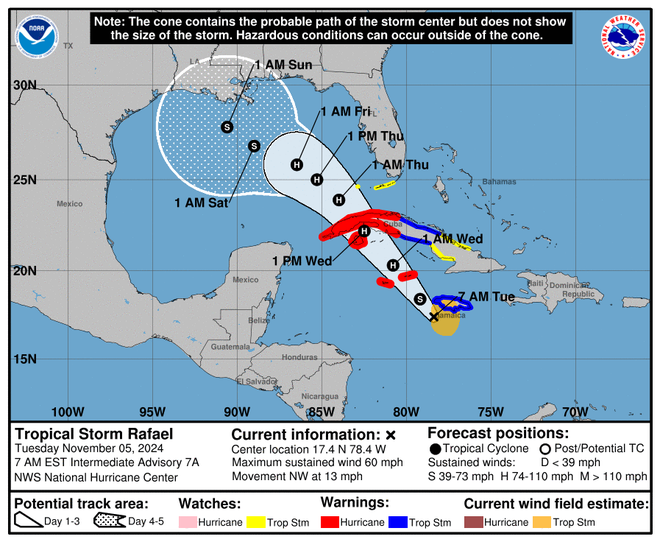
Tropical Storm Rafael strengthened Tuesday on its path toward the Cayman Islands and Cuba as weather officials in the U.S. monitored the storm for potential impacts to the Gulf Coast.
Rafael was forecast to swipe Jamaica on Tuesday afternoon before intensifying into a hurricane near the Cayman Islands and gaining more steam ahead of its expected landfall in Cuba on Wednesday.
With much uncertainty in the long-range forecast, the National Hurricane Center in Miami said it's too early to determine what, if any, impacts Rafael could bring to portions of the northern Gulf Coast.
Forecasts show the storm could make landfall anywhere from the Texas coast to the Florida Panhandle around the weekend, according to AccuWeather, which said the highest probability of landfall is along the central Louisiana coast. Other possible scenarios include the storm turning west and moving over the western coast of Mexico.
More:Tropical Storm Rafael tracker: Storm passing near Jamaica, Cayman Islands Tuesday
The good news: Drier air and stronger vertical wind shear in the Gulf are expected to limit the hurricane's strength. "This will not be a situation where there is a strengthening major hurricane that makes landfall in the U.S., but rather something less intense in terms of wind intensity," AccuWeather's forecast says.
Still, the storm is threatening to bring flooding rain, mudslides, damaging winds and dangerous surf and rip currents to western Cuba, which is still reeling from the collapse of its electrical grid and Hurricane Oscar.
The Cayman Islands and much of Cuba were under hurricane warnings Tuesday morning, according to the hurricane center, which urged that "Preparations to protect life and property should be rushed to completion." Tropical storm warnings and watches were active across Jamaica, parts of Cuba and the Florida Keys.

Where is Tropical Storm Rafael?
Tropical Storm Rafael was located about 70 miles southwest of Montego Bay, Jamaica, and some 150 miles east-southeast of Grand Cayman island, according to the hurricane center's 1 p.m. EST update. With winds of 60 mph, the storm is moving northwest through the Caribbean at 14 mph.
Rafael is forecast to pass near Jamaica on Tuesday, bringing torrential rainfall that could trigger mudslides along the higher terrain of the island country. Minor coastal flooding is a possibility.
As the storm pushes north over the warm Caribbean waters, it's forecast to intensify and be near hurricane strength when it crosses near or over the Cayman Islands on Tuesday night, unleashing hurricane-force winds, storm surge and destructive waves, the hurricane center said.
On Wednesday, the storm is expected to strengthen further before it makes landfall along western Cuba, where meteorologists say Rafael could raise water levels by as much as 6 to 9 feet above normal tide. Cuba, as well as parts of Jamaica and the Cayman Islands, could see between 3 to 6 inches of rain, with isolated totals of up to 10 inches.

Later on Wednesday, the storm will pass by the Florida Keys, bringing 1 to 3 inches of rain to the islands, according to the hurricane center, which added, "a few tornadoes are possible Wednesday over the Keys and southwesternmost Florida mainland."
Rafael is the 17th named storm of the 2024 Atlantic hurricane season, according to Colorado State University hurricane researcher Phil Klotzbach. An average year sees 14 storms.
How will Rafael impact Florida?
For the Florida Peninsula, Rafael will make its closest approach late Wednesday and Thursday, bringing increased chances of rain to the state as it lashes the Florida Keys with strong winds. Ryan Truchelut, a Florida meteorologist who works with the USA TODAY Network, said Rafael is forecast to remain well southwest of the Keys.
Tropical storm conditions are expected in the lower and middle islands on Wednesday, according to the hurricane center. A few tornadoes are possible Wednesday over the Keys and southwestern Florida's mainland.
Heavy rainfall will spread north into Florida and adjacent areas of the Southeast U.S. during the middle to latter part of the week, the hurricane center said.
"The good news is that while Rafael may well enter the Gulf as a hurricane mid-week, there is very little chance of the storm reaching land as a hurricane," Truchelut said.
– Cheryl McCloud, USA TODAY Network-Florida
Cuba grapples with power grid collapse as Rafael approaches
Rafael's approach toward western Cuba comes as the nation tries to recover from blackouts and Hurricane Oscar, which coincided two weeks ago as the country struggles with food, fuel and medicine shortages.
Some 10 million people were without power for days as the hurricane inundated regions of the country with flooding rain. Outages still abound across Cuba weeks later.
Schools and public transportation services announced cancellations and pauses in service ahead of Rafael. Meanwhile, plans were underway to evacuate thousands of residents in vulnerable parts of the island country, especially areas where the ground remains saturated from Oscar's rain.
Residents of western Cuba said they were preparing for the worst.
"We are working together among neighbors ... taking in those who live in poorly built homes," Natacha Velazquez, whose house fronts the ocean in Baracoa just west of the capital, told Reuters on Monday evening. "But we are also worried for our lives."
Tropical Storm Rafael tracker

Contributing: Reuters; Doyle Rice and Gabe Hauari, USA TODAY.
(This story was updated to add new information.)
Disclaimer: The copyright of this article belongs to the original author. Reposting this article is solely for the purpose of information dissemination and does not constitute any investment advice. If there is any infringement, please contact us immediately. We will make corrections or deletions as necessary. Thank you.


