Hurricane Rafael slams into Cuba as Category 3 storm: Will it hit the US?
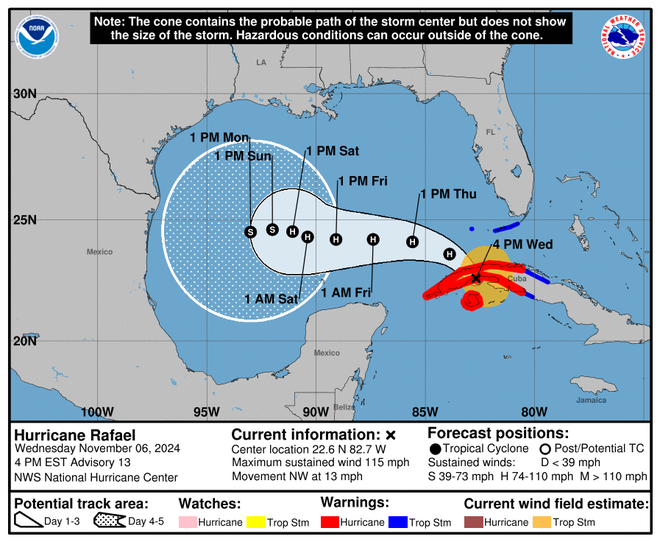
Hurricane Rafael made landfall in western Cuba as a Category 3 storm Wednesday, bringing sustained winds of up to 115 mph as it batters the already ravaged island before heading to the Gulf of Mexico and churning toward the U.S.
The National Hurricane Center said at 4:15 p.m. the storm struck the Cuban province of Artemisa just east of Playa Majana.
Located 40 miles southwest of Havana and 30 miles southeast of Bahia Honda, Rafael carries a high chance of producing "life-threatening storm surge'' of 6-10 feet in some areas, flash flooding and mudslides, the center said.
Rafael was a tropical storm Tuesday afternoon but rapidly intensified over the Caribbean waters, which are a bit warmer than usual for this time of year with temperatures in the mid 80s. The storm's maximum sustained winds increased 55 mph in 24 hours.
The blow from Rafael comes as Cuba is still recovering from the collapse of its electrical grid and the impact of Hurricane Oscar, a Category 1 storm that inundated the country with heavy rain and killed at least six people last month. The saturated ground will increase the likelihood Rafael will trigger flash flooding and mudslides, officials said.
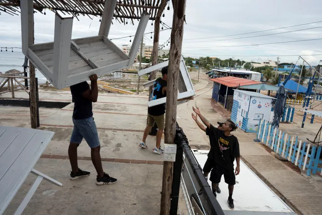
More than 60,000 residents evacuated Guantánamo, the easternmost province of Cuba, as persistent thunderstorms unleashed dangerous floods over the weekend and in the wake of Oscar. Ahead of Rafael, government offices and schools across the country announced closures and some public transportation services were halted.
Hurricane Rafael tracker:Storm expected to make landfall in western Cuba Wednesday

Will Rafael hit the US?
After passing over western Cuba on Wednesday afternoon, Rafael is predicted to enter the Gulf of Mexico on Wednesday night still as a hurricane, despite weakening some over the island. The NHC says the storm will bring tropical storm conditions to the Florida Keys and could possibly spin up tornadoes across the state's southwestern mainland.
Rafael is expected to follow a northwestern path after leaving Cuba and "meander over the south-central Gulf of Mexico this weekend and early next week,'' the hurricane center said, adding that those in the southern and southwestern parts of the Gulf should keep track of its progress.
As the storm churns in the Gulf, it is expected to weaken as it encounters wind shear, drier air and cooler waters. Long-range forecast models are not in agreement and show the storm could have direct impacts anywhere from eastern Mexico to Texas, Louisiana, Mississippi and the Florida Panhandle.
"Once in the Gulf of Mexico, slight differences in Rafael's intensity and atmospheric steering winds could have a significant impact on its final track," said Bill Deger, a meteorologist with AccuWeather. "It is also possible Rafael is torn apart by strong winds high in the atmosphere and dissipates in the Gulf of Mexico before making landfall."
AccuWeather says steering winds from a storm over the south-central U.S. are raising uncertainty in the forecast track. The hurricane center cautioned there was also "larger-than-normal uncertainty regarding Rafael's intensity later in the forecast period."
Despite its expected weakening in the Gulf, Rafael and its winds will be large and strong enough to create rough seas and life-threatening surf and rip current conditions, according to the hurricane center.

Rafael contributes to heavy rain expected in Southeast US
Heavy rain is forecast Wednesday night and into Thursday across the Southeast as a result of an interaction between a trough over the region and a broad area of disturbed weather across the tropics, said Marc Chenard, a meteorologist at the Weather Prediction Center.
The potential exists for 4-8 inches of rain, with up to 10 inches in isolated locations across the Florida Panhandle, and possibly more than 8 inches in locations extending northeastward into the South Carolina low country overnight Wednesday and into Thursday.
A corridor of mid-level and upper-level winds is expected to help generate the moisture, and then moisture from the Caribbean and tropical Atlantic is forecast to further enhance the rainfall. Chenard said Rafael, embedded within that broader area of disturbed weather, is playing at least some role by helping to enhance the moisture from the tropics.
− Dinah Voyles Pulver
Behind Rafael, another storm is brewing in the Caribbean
Meteorologists were monitoring a storm brewing in the Caribbean Sea as Rafael barreled toward Cuba.
The system of low pressure producing showers and thunderstorms was located a few hundreds miles east-northeast of the Leeward Islands as of Wednesday afternoon, according to the National Hurricane Center.
Federal forecasters say the system could gradually develop as it moves west near the Virgin Islands and Puerto Rico before approaching the Bahamas, but chances of formation over the next week are only 30%.
Rafael was the 17th named storm of the 2024 Atlantic hurricane season, according to Colorado State University hurricane researcher Phil Klotzbach. An average year sees 14 storms.
Rafael was also the 11th hurricane of the season, well above the average of seven. This year has been an extremely active hurricane season, which meteorologists have credited in part to record warm water temperatures. Since accurate records began in 1851, only seven other seasons have had as many as 11 Atlantic hurricanes by this date, Klotzbach said.
Hurricane Rafael storm tracker

Contributing: Gabe Hauari, Doyle Rice and Dinah Voyles Pulver, USA TODAY; Reuters
(This story was updated to add new information.)
Disclaimer: The copyright of this article belongs to the original author. Reposting this article is solely for the purpose of information dissemination and does not constitute any investment advice. If there is any infringement, please contact us immediately. We will make corrections or deletions as necessary. Thank you.


