'Be vigilant': Idalia intensifying, could slam Florida as major hurricane. Live updates
FORT MYERS, Fla. − Tropical Storm Idalia was intensifying Monday and threatened to slam across Florida's Gulf Coast sometime Wednesday as a major hurricane with "life-threatening storm surge and dangerous winds," the National Hurricane Center said.
The storm was forecast to reach hurricane strength later Monday, hurricane center forecaster Eric Blake wrote in a morning advisory
Hurricane watches were in effect along more than 300 miles of the Florida Coast − from Longboat Key, 60 miles south of Tampa, to the Ochlockonee River near Tallahassee. A major hurricane is a Category 3, 4 or 5 storm or higher on the Saffir-Simpson hurricane wind speed scale. A storm becomes a Category 3 hurricane when when maximum wind speeds reach at least 111 mph.
"Hurricane conditions are expected somewhere within the warning area ... within the next12-24 hours," Blake said. "Preparations to protect life and property should be rushed to completion."
Tampa Mayor Jane Castor declared a state of emergency for the city. A surge of up to 7 feet is possible in the Tampa Bay area, and any shift eastward in the storm’s path could increase the dangers for the sprawling metropolitan area.
Pasco County, north of Tampa, issued a mandatory evacuation order for some areas − and throughout the county of almost 600,000 people for those living in manufactured or mobile homes or RVs. The county will open shelters Tuesday morning.
"Please consider riding out the storm with family or friends," county officials said in a statement. "If that’s not an option, you can evacuate directly to a Pasco County shelter."

Spaghetti models:See latest satellite images, spaghetti models for Idalia
Developments:
∎ Up to 11 feet of ocean water could surge over the Florida shoreline and along inland rivers and creeks as the storm rolls in, raising concerns for flooding that could be extensive.
∎ Early Monday the storm's center was located 80 miles south of the western tip of Cuba. Idalia was moving toward the north at 7 mph with sustained winds of 65 mph.
∎ The storm's center was forecast to crash over or near western Cuba on Monday night and into the southeastern Gulf of Mexico by early Tuesday. Idalia was forecast speed up and turn north-northeastward as it roars toward Florida.
Idalia has 'infernal potential':Storm takes aim at Florida, forecaster warns
How do hurricanes form?An inside look at the birth and power of ferocious storms
Message to Pine Island residents: Don't panic
Some barrier islands along Southwest Florida, like Pine Island, Matlacha, Sanibel and Fort Myers Beach saw widespread devastation from Hurricane Ian's heavy winds and 14-foot-high storm surge less than one year ago. Now, faced with Hurricane Idalia, local leaders are urging people to stay calm, but prepare. Jen and Kevin Russell, who run the popular 'Things to do on Pine Island' Facebook page, are considered the unofficial mayors of the unincorporated island. The Russells' message to Pine Islanders was simple: don't panic. "We don't want to create any anxiety for people," said Jen, adding that fear might keep people from smart decisions.Kevin said at the moment they planned to keep Pine Islanders informed through their Facebook page, as they did during Ian.
Tampa airport, port announce closures ahead of Idalia
Tampa International Airport will shut down at 12:01 a.m. Tuesday and expects to reopen Thursday morning following assessments of the damage, authorities said. Port Tampa Bay already has closed for inbound ships because of the coming storm, although "landside" operations such as fueling remain open, authorities said. The Coast Guard has set the port conditions to YANKEE, meaning gale force winds are possible within 24 hours.
"The port has been in contact with our partner fuel terminal operators and have been assured they are prepared to deliver fuel and support consumers," the port said in a statement.

Sanibel, blasted by Ian, awaits Idalia
Sanibel city council member Holly Smith, who was mayor when Hurricane Ian devastated the island in September, said as a hotelier she’s busy doing prep while navigating a flurry of meetings Monday. On the schedule so far: the fire district, Lee County Electric Cooperative, a likely City Council meeting and a roundtable with Senator Rick Scott about lessons, learned from hurricane Ian. She said she has asked Lee County officials for a state of emergency to prepare for evacuations and other responses as the storm grows stronger.
She estimated there are about 1,000 residents on the island and fewer than 100 visitors due to limited room availability.
After Ian, “I would rather have a citizen upset with me for a couple of days if nothing comes to pass, then have to handle the mess we did post-Ian," she said.
Coastal areas brace for flooding from storm surge
Storm surge – a rapid increase in water levels that push inland up rivers and streams – will create a serious flooding threat along Florida’s west coast. The National Hurricane Center increased and extended its surge forecast Monday with the expectation that Idalia will become a major hurricane, with winds in excess of 110, as it nears the coast. Idalia will be making landfall during a full moon, the time of the month when tides are at their highest.
The center warned the surge could be as high as 7-11 feet from the Big Bend south to Homosassa Springs, and a storm surge warning is in place from St. Marks, Florida south to Port Charlotte. The surge could be on the higher end of the forecast if Idalia makes landfall at high tide.
The peak surge forecast decreases by degrees further south along the coast, but could be anywhere from 3 feet to 9 feet, depending on the proximity to landfall, the hurricane center said.
− Dinah Pulver
Neighbor helping neighbor in Manatee County
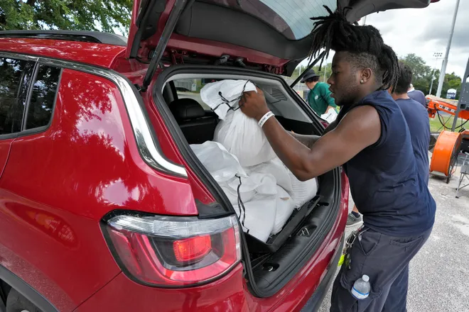
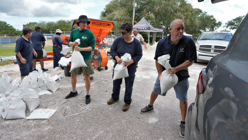
Dave Clement, 66, lives on the second level of a condo building in Bradenton Beach south of Tampa. He drove a couple miles south to Coquina Beach, where Manatee County workers dumped sand and bags for locals preparing for the storm. Clement said he was shoveling sandbags for his downstairs neighbor, who was traveling.
Clement said that, while it remained unclear where the storm will hit, it was best to prepared for whatever might come.
"When you live in a condo association, you know, you’re all connected,” Clement said. “That’s how I look at it. You want to make sure your neighbor’s going to be okay.”
− Sarasota Herald-Tribune staff
State expects power outages, preps for water rescues
Gov. Ron DeSantis, who has declared a state of emergency for half the state's counties, warned that trees will come down and power outages are "just going to happen." The state mobilized 1,100 National Guard members with 2,400 high water vehicles and 12 aircraft to prepare for rescues, he said. The state's emergency operations center in Tallahassee shifted into around-the-clock operations Monday morning.
"These things can wobble, so Floridians along our Gulf Coast should be vigilant, even if you are currently outside" the likely track of the storm, he said.
Damaging winds, up to 18 inches of rain
"Major, life-threatening flooding" was possible, with 4 to 8 inches of rain possible from northern Florida through the Southeast − and some areas could see up to 18 inches of rain, AccuWeather said. AccuWeather Meteorologist Brandon Buckingham said damaging winds of 40 to 60 mph can be expected across Florida and parts of the Southeast in coming days.
"Closest to where the tropical system makes landfall, however, wind gusts of up to 120 to 140 mph can occur," he said.
What is storm surge?Explaining a hurricane's deadliest and most destructive threat
Contaminated gas complicates storm preparations
Drivers along Florida's Gulf Coast were told they could have purchased gas contaminated with diesel fuel over the weekend as residents in the area prepared for Idalia to make landfall. Florida officials warned Sunday that any fuel purchased after 10 a.m. on Saturday at stations supplied by Citgo from the Port of Tampa has a strong likelihood of being contaminated with diesel fuel.
The Florida Department of Agriculture and Consumer Services stated that contaminated gasoline and diesel have the potential of causing engine damage or affecting operability.
− Sarasota Herald-Tribune staff
Idalia will also target Georgia, Carolinas, Virginia
Georgia, South and North Carolina and Virginia will be the next targets as Idalia sweeps over Florida, forecasters say. Up to 8 inches and wind gusts of more than 40 mph are likely through eastern Georgia and the Carolinas and possibly Virginia later in the week and approaching Labor Day weekend.
"By late week, the storm can turn toward the east and re-emerge over the Atlantic Ocean," Buckingham said. "At this point, little re-intensification can be expected, and the system will be moving away from the East Coast toward Bermuda."
Hurricane Franklin is season's first 'major' hurricane
Hurricane Franklin was rapidly intensifying early Monday and reached Category 4 strength with maximum sustained winds estimated at 145 mph. The first "major" hurricane of the season, the storm was centered more than 400 miles north of Grand Turk Island and moving north-northwest at 8 mph. Later this week Franklin will hit Bermuda, AccuWeather said. Franklin is also expected to have an impact on the U.S. East Coast, where "rough surf and rip currents could imperil swimmers as summer winds down," AccuWeather warned.
What is the Saffir-Simpsonhurricane wind speed scale? Breaking down the hurricane category scale
Contributing: Cheryl McCloud, USA TODAY NETWORK - Florida
Disclaimer: The copyright of this article belongs to the original author. Reposting this article is solely for the purpose of information dissemination and does not constitute any investment advice. If there is any infringement, please contact us immediately. We will make corrections or deletions as necessary. Thank you.


