Hurricane Idalia takes aim at Florida as evacuations ordered, schools close
Hurricane Idalia is gaining strength as it moves toward Florida, where residents are scrambling to prepare for the impacts of what is forecast to be a major storm. Idalia is expected to grow into an extremely dangerous hurricane before it makes landfall on Florida's Gulf Coast on Wednesday, according to the National Hurricane Center.
"Life-threatening" storm surge and hurricane conditions are expected along parts of the Gulf Coast Tuesday night and Wednesday, the hurricane center said.
Florida Gov. Ron DeSantis has declared a state of emergency covering 49 counties. Evacuation notices have been issued in 28 counties, with mandatory orders in effect for some people in eight of them, The Associated Press reports.
At a briefing Tuesday evening, he urged people to leave immediately if they were in an evacuation zone.
"If you stay hunkered down tonight, it's going to be too nasty tomorrow morning to be able to do it," DeSantis said.
"If you do choose to stay in one of the evacuation zones, first responders will not be able to get you until after the storm has passed."
Tolls were suspended early Tuesday morning along Florida's west coast, according to the governor's office, and 50 shelters have opened.
Schools across more than three dozen Florida counties are also closed this week. Many will be shuttered at least through Wednesday, according to the Florida Department of Education.
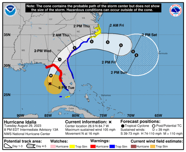
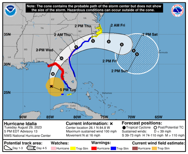
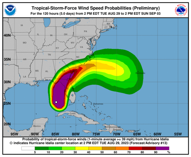
Hurricane path and map
Idalia is expected to make landfall along the Gulf Coast of Florida on Wednesday, likely centered in the Big Bend area, with hurricane conditions extending along the coast.
You can see a live feed of Hurricane Idalia radar tracking in the video below:
The storm could arrive on Wednesday morning between 7 a.m. and 11 a.m. ET, CBS News senior weather and climate producer David Parkinson said.
Hurricane maps show the projected path of the storm and its impacts.


What category of storm will Hurricane Idalia be?
Hurricane Idalia is forecast to strengthen into at least a Category 3 hurricane.
"This is going to be a major impact," DeSantis said at a news conference Monday. "And Floridians should expect that this storm will be a major Cat 3+ hurricane, so please prepare accordingly."
Category 3 storms have sustained wind speeds of 111-129 mph and are expected to produce devastating damage, including downed trees, major damage to homes and days- or weeks-long cuts to electricity and water, the hurricane center says.
A Category 3 storm — like a Category 4 or 5 — is considered a "major" hurricane due to the potential for "significant loss of life and damage," the National Hurricane Center says.
Hurricane watches and warnings are in effect for parts of Florida's Gulf Coast as the storm is strengthening.
State of emergency in effect
DeSantis expanded a state of emergency to cover 49 Florida counties. He first issued a state of emergency on Saturday for 33 of the state's 67 counties to ensure communities "have time to prepare for the storm system which could have impacts along the Gulf Coast next week."
The Florida National Guard says it is deploying 5,500 personnel to support areas of the state that are impacted. Additionally, 14 aircraft, 2,400 high-wheel vehicles and 23 small watercraft were being mobilized.
North Carolina Gov. Roy Cooper also declared a state of emergency ahead of Hurricane Idalia, as did Georgia Gov. Brian Kemp.
"We are taking every precaution ahead of Hurricane Idalia's landfall tomorrow, and I am taking this additional executive action to ensure state assets are ready to respond," Kemp said Tuesday in a news release.
Parts of Florida's west coast and the Florida Panhandle — as well as southeast Georgia and the eastern Carolinas — could see up to 8 inches of rainfall from Tuesday through Thursday, with up to 12 inches possible mostly in areas near where the storm makes landfall, the National Hurricane Center says. That could lead to flash and urban flooding, "some of which may be locally significant."
Storm surge is also expected. The water level could reach as high as 15 feet in the area between the Aucilla River and Yankeetown, Florida, if storm surge coincides with high tides. It could reach as high as 11 feet in other areas, and 7 feet in Tampa Bay, according to the hurricane center.
Tornado watches were issued for a large portion of the Florida Gulf Coast on Tuesday night that would be in effect until 6 a.m. ET as the storm approached.
A tornado watch has been issued for parts of Florida until 6 AM EDT pic.twitter.com/QnqruTvWSm
— NWS Tornado (@NWStornado) August 30, 2023
What is storm surge?
Storm surge is "an abnormal rise of water generated by a storm," according to the National Hurricane Center. As a storm moves toward the coast, water is pushed to the shore and "piles up," which creates a surge.
If a storm surge and high tide take place at the same time, water levels will be even higher. The combination is known as storm tide.
Storm surge is one of the deadliest hazards of a hurricane. It is also "a very complex phenomenon," according to the hurricane center," because it depends on factors including a storm's wind speeds, size and angle of approach to the coastline, as well as the shape and characteristics of the coast.
A storm surge warning is in effect for Englewood north to Indian Pass, Florida. A storm surge watch is in effect for Chokoloskee to Englewood, including Charlotte Harbour, as well as for the mouth of the St. Mary's River to South Santee River, South Carolina.
Nicole Brown Chau contributed to this report.
- In:
- National Oceanic and Atmospheric Administration
- Gulf of Mexico
- Florida
- Hurricane
Disclaimer: The copyright of this article belongs to the original author. Reposting this article is solely for the purpose of information dissemination and does not constitute any investment advice. If there is any infringement, please contact us immediately. We will make corrections or deletions as necessary. Thank you.


