Hurricane Idalia slams Florida's Gulf Coast, moves into Georgia. Here's what meteorologists say is next.
Hurricane Idalia made landfall Wednesday morning as a powerful Category 3 storm in Keaton Beach, located along Florida's Gulf Coast near Tallahassee. After rapidly intensifying on its path through the warm waters of the Gulf of Mexico, and briefly registering as a Category 4 storm, the hurricane hit Florida's Big Bend area with maximum sustained winds of 125 miles per hour.
The storm was downgraded to a Category 1 hurricane about 2 1/2 hours after landfall, as wind speeds decreased to 90 mph, and they continued to decline to about 85 mph.
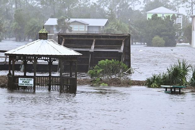
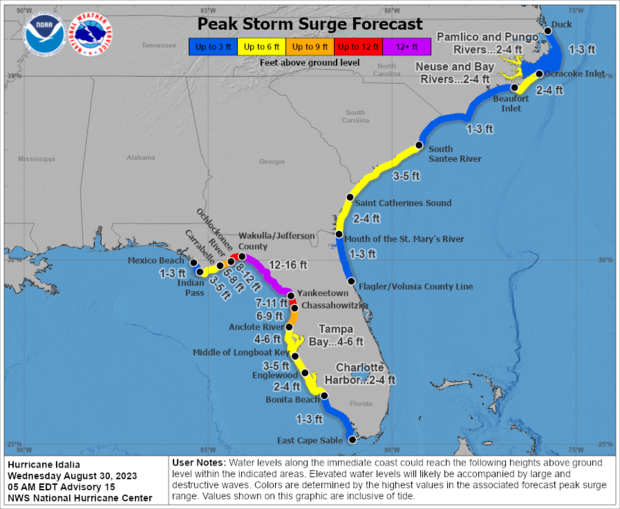
Videos and photos showed flooding and damage as the storm brought strong winds, heavy rain and storm surge to the Big Bend region — the stretch of the Gulf Coast where the Florida peninsula meets the panhandle. Storm surge in the area was forecast to reach up to 12 to 16 feet, with higher levels expected later in the day at high tide.
At a news conference Wednesday afternoon, Florida Gov. Ron DeSantis and other state officials said efforts were underway to restore power and roadways in areas hit by the storm.
"We're still assessing what is all going on on the ground in the places that had the initial impact," said DeSantis. At the time, he said there were no confirmed fatalities linked to Hurricane Idalia. The governor said any deaths would need to be confirmed by medical examiners with the Florida Department of Law Enforcement.
Electrical outages were widespread. More than 280,000 customers around that area had lost power as of midday, with another 92,000 outages reported in Georgia, according to the tracking site PowerOutage.us.
Where did Hurricane Idalia make landfall?
Idalia made landfall on Florida's Gulf Coast at around 7:45 a.m. ET near Keaton Beach, roughly 75 miles southwest of Tallahassee, Florida's capital city, according to the National Hurricane Center.
The city of Perry, located about 50 miles southeast of Tallahassee, appeared to be hit hardest by Idalia, said Kevin Guthrie, director of the Florida Division of Emergency Management, at the governor's afternoon briefing. Guthrie told reporters at the time that the state was coordinating with law enforcement and emergency personnel in Perry to respond to reports of businesses that caught fire or lost their roofs in the hurricane, in addition to one unconfirmed report of a structure collapse.
Madison County, about 35 miles inland, was also weathering impacts from the storm, including "a lot of debris on the ground" and near-total loss of power, Guthrie said.
Water levels along the coast of Florida's Big Bend region were rising quickly Wednesday morning, and recent reports from a tide gauge operated by the National Oceanic and Atmospheric Administration indicated that levels reached 6.8 feet above the "mean higher high water, which is an approximation of inundation in that area," the National Hurricane Center said.

The latest report from Cedar Key showed water levels have risen almost a foot since the hurricane made landfall, with high tide still to come in the afternoon.
The hurricane center previously warned of "catastrophic storm surge and destructive winds occurring in the Florida Big Bend region."
Storm surge — rising water levels caused by hurricane-force winds that push water toward shore and over dry land — was forecast to reach up to 16 feet in some areas of Florida's Big Bend region. The phenomenon, which can occur before, during and after a storm, is considered the greatest threat to life during a hurricane.
"That level of storm surge is life threatening," Florida Gov. Ron DeSantis said at an early morning briefing, adding, "There will be impacts far behind the eye wall, and those will extend to places like Tallahassee" and other parts of northeast Florida.
Meteorologists said strong winds generated by the hurricane would spread inland, impacting parts of northern Florida and southern Georgia near the track of Idalia's core. Damaging hurricane-force winds could extend as far as southeastern South Carolina, they added.
The National Hurricane Center said portions of the Florida Gulf Coast where storm surge warnings are in place will continue to feel "significant impacts" of rising water levels through Wednesday evening, adding that "dangerous storm surge" is also expected along the southeastern U.S. coast, where warnings are also active, on Wednesday night and into Thursday.
Hurricane Idalia's projected path after landfall
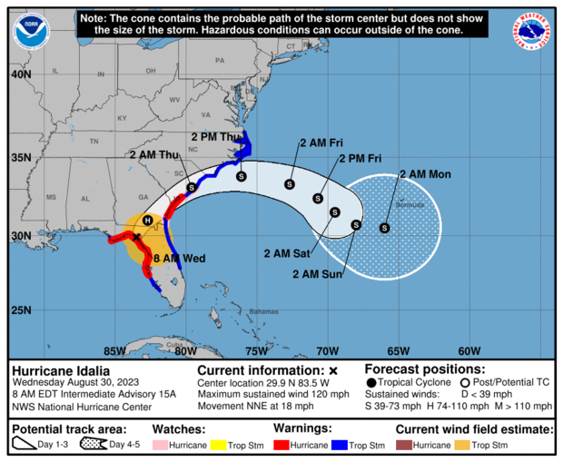
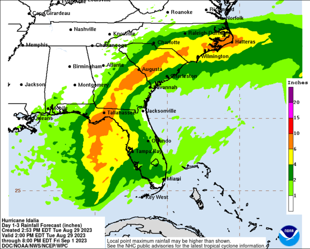
National Hurricane Center forecasters say Idalia is expected to continue on a northeasterly path after making landfall. Its impact will be felt across much of the northern and central parts of the state, with high winds and heavy rain in addition to dangerous storm surge in coastal areas.
Meteorologists warned "damaging winds" were already spreading into southern Georgia on Wednesday morning. The center of Idalia was crossing over the border into Georgia by 11 a.m. ET, the hurricane center said, adding that the storm continued to drive up water levels along Florida's Gulf Coast.

Flash flood warnings were in effect Wednesday and expected to remain in place through the afternoon for parts of northwestern Florida, including Tallahassee, as well as southern Georgia.
The National Weather Service in Tallahassee reported significant spikes in water levels along the nearby Steinhatchee River after Idalia's landfall. Meteorologists previously warned of potentially "unprecedented" weather event in that area, saying a hurricane of Idalia's size had never entered the Apalachee Bay, located just south of the capital city.
"In this part of Florida, particularly the Big Bend coast, we haven't seen a hurricane landfall of this intensity in many, many, many years," Michael Brennan, director of the National Hurricane Center, told "CBS Mornings" on Wednesday. Brennan noted the continental shelf in that area of Florida's Gulf Coast amplifies the storm's impact and makes the region more susceptible to devastating storm surge.

"We're gonna see, you know, not just the storm surge but potential for damaging winds extending well inland all the way across portions of north Florida, into southern Georgia, into places like Savannah, Hilton Head. We have hurricane warnings in effect for the fast-moving hurricane. It's going to bring those winds really far inland today and tonight," said Brennan.
In Crystal River, north of Tampa, city manager Doug Baber told "CBS Mornings" that the most severe storm surge threats will come later in the day on Wednesday, during high tide.
Later Wednesday and into Thursday, Idalia is then forecast to track across southeast Georgia and the coast of South Carolina and the southeastern portion of North Carolina before moving out to sea.

Hurricane Idalia wind speeds
Before reaching Florida, Idalia intensified in the Gulf of Mexico from tropical storm to hurricane strength Tuesday morning. It strengthened further to a Category 2, with sustained winds of 100 mph, on Tuesday afternoon. Overnight, it rapidly intensified to a Category 3 and then Category 4, with winds of 130 mph early Wednesday, before retreating slightly back to Category 3.
The hurricane center later downgraded Idalia to a Category 2 storm, as its maximum sustained winds dropped to 110 mph, and, later, 105 mph, with higher gusts recorded. It was further downgraded to Category 1 at around 11 a.m. ET, as maximum sustained winds fell to 90 mph, according to the National Hurricane Center. By noon, maximum sustained wind speeds were at 85 mph.
Category 3 means a hurricane has maximum sustained winds between 111 mph to 129 mph. Category 2 corresponds with maximum sustained winds between 96 mph and 110 mph, while Category 1 storms have maximum sustained winds between 74 mph and 95 mph.
Any storm that reaches a Category 3 or higher the Saffir-Simpson Hurricane Wind Scale — which runs from 1 to 5, based on a storm's wind speeds — is considered a "major hurricane," with the potential for "significant loss of life and damage," the National Hurricane Center says.
With a Category 3 storm, "Devastating damage will occur," the hurricane center warns. "Well-built framed homes may incur major damage or removal of roof decking and gable ends. Many trees will be snapped or uprooted, blocking numerous roads. Electricity and water will be unavailable for several days to weeks after the storm passes."
How long is Hurricane Idalia supposed to last?
Idalia is likely to still be a hurricane as it moves across southern Georgia, and possibly when it reaches the coast of Georgia or southern South Carolina on Wednesday, the National Hurricane Center said.
Idalia is expected to turn more toward the east and move offshore into the Atlantic on Thursday, decreasing in strength as it travels.
- See Hurricane Idalia from space: Video from International Space Station shows storm off Florida coast
- In:
- Florida
- Hurricane
Disclaimer: The copyright of this article belongs to the original author. Reposting this article is solely for the purpose of information dissemination and does not constitute any investment advice. If there is any infringement, please contact us immediately. We will make corrections or deletions as necessary. Thank you.


