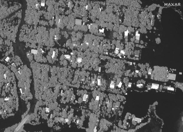
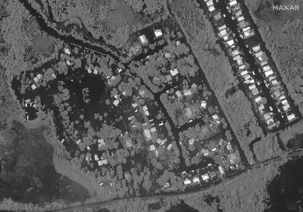
Satellite images capture massive flooding Hurricane Idalia heaped on Florida's Big Bend when it made landfall
Striking photos show water-logged communities after Hurricane Idalia brought disastrous flooding and powerful winds to the Gulf Coast of Florida on Wednesday, when it made landfall along the state's Big Bend region as a dangerous Category 3 storm.
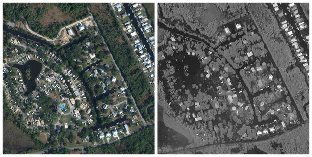
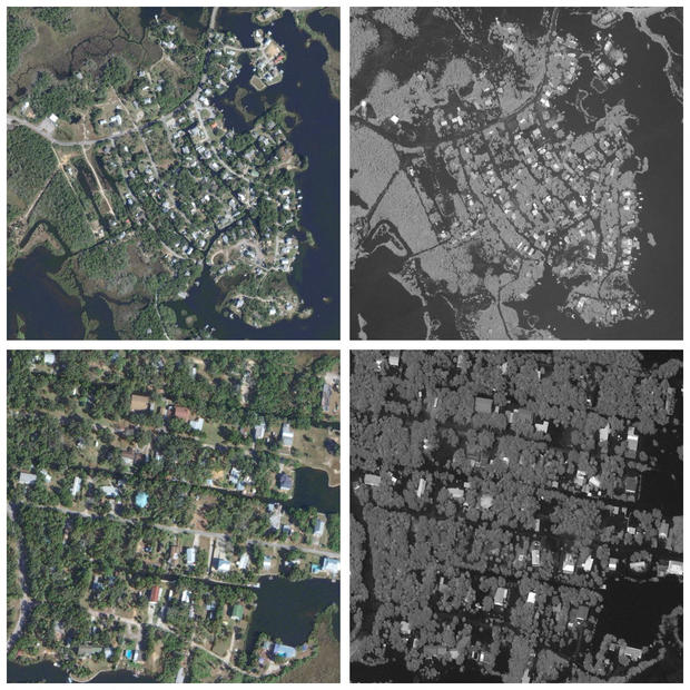
Satellite images captured the damage in some hard-hit areas, including Ozello and Crystal River, two neighboring coastal communities that sit less than 100 miles north of Tampa Bay.

Idalia made landfall as a Category 3 hurricane
After initially striking land with maximum sustained winds of 125 miles per hour, Idalia gradually decreased in strength while tracking north into Georgia and eventually moving into South Carolina on Wednesday night. Meteorologists downgraded the hurricane to a tropical storm in the late afternoon as wind speeds declined.
Videos and photos of the storm's aftermath showed flooded streets from Tampa to Tallahassee, Florida's capital city, as well as downed trees and power lines and damaged homes across the area. The National Weather Service had warned of "catastrophic storm surge and destructive winds" impacting the Big Bend region — where the Florida peninsula meets the panhandle — as a result of the hurricane.

The center of Idalia crossed over the border into Georgia by 11 a.m. ET on Wednesday, according to the hurricane center, which said at the time that the storm was continuing to increase water levels along Florida's Gulf Coast. Idalia had crossed into South Carolina by 8 p.m. ET.
Although the National Weather Service in Tallahassee cancelled hurricane and tropical storm warnings for the surrounding area several hours prior, the agency said concerns remained about the potential for "lingering coastal flooding, especially at high tides."
Before-and-after flooding images
Storm surge in parts of Florida's Big Bend area was forecast to reach between 12 and 16 feet, with meteorologists cautioning that surge generated by Idalia could be devastating if it were to coincide with high tides. Storm surge, which refers to rising water levels occurring when hurricane-force winds push water toward the shore and over areas of normally dry land, is considered the greatest threat to life during a hurricane. It can happen before, during or after a storm.
Michael Brennan, director of the National Hurricane Center, told "CBS Mornings" on Wednesday that the topography of the continental shelf in the Big Bend region of Florida's Gulf Coast makes the area more susceptible to devastating storm surge during hurricanes and would amplify the impacts of Idalia.

"In this part of Florida, particularly the Big Bend coast, we haven't seen a hurricane landfall of this intensity in many, many, many years," Brennan said.
In Crystal River, about 10 miles northeast of Ozello, City Manager Doug Baber told "CBS Mornings" ahead of Idalia's landfall that the most severe storm surge threats would come later in the day on Wednesday, during high tide.

"The surge is going to be pushing in later today. The biggest part of the surge is going to be around 4:30 ... due to the high tide," he said, warning people to remain vigilant and cautioning against a false sense of confidence that could lead residents to go out on the roads before the surge arrived.
In addition to satellite images, photos shared to Facebook by city officials in Crystal River showed main streets completely flooded, with storefronts partially submerged in water.
"The end of a sad day for Crystal River," wrote Crystal River Mayor Joe Meek in a post shared Wednesday night, which appeared to show people sitting in a raft in the middle of an inundated roadway. "The clean up starts tomorrow, and I can promise you this; we will be stronger and better than ever! Proud of our city and look forward to getting to work!"
With the community we have, We will come back stronger than ever.
Posted by City of Crystal River-Government on Thursday, August 31, 2023
- In:
- Tropical Storm
- Florida
- Hurricane
- Tampa Bay
- Tallahassee
Disclaimer: The copyright of this article belongs to the original author. Reposting this article is solely for the purpose of information dissemination and does not constitute any investment advice. If there is any infringement, please contact us immediately. We will make corrections or deletions as necessary. Thank you.


