Hurricane Lee updates: No direct hit expected, but rip currents headed to East Coast
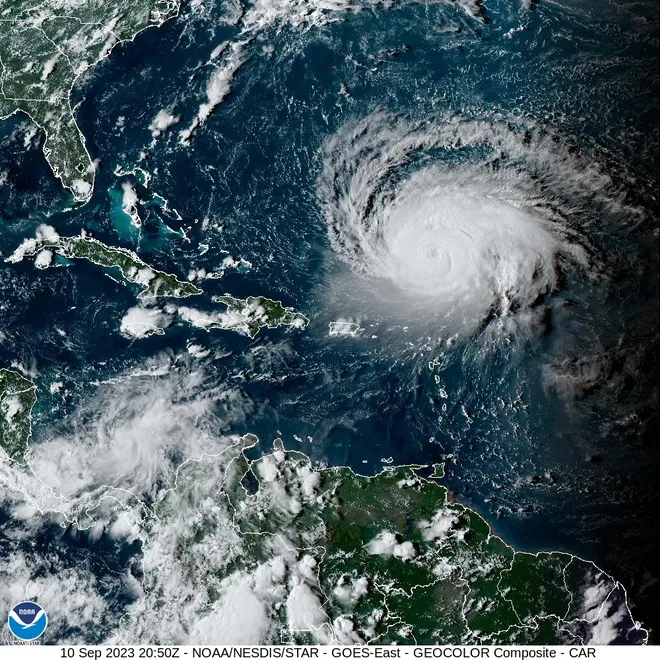
One of the most powerful hurricanes in recent years was rolling north in the Atlantic Ocean on Sunday, gaining strength but not expected to unleash its full fury across U.S. shores.
The reprieve was not complete. Dangerous surf and rip currents were forecast along much of the U.S. East Coast.
"Starting as early as Sunday, seas and surf will build to dangerous levels along the central and northern coast of Florida," AccuWeather senior meteorologist Joe Lundberg said. The rough seas were forecast to spread north across the mid-Atlantic and New England coasts later in the week, he said.
Waves of up to 20 feet were forecast for Puerto Rico, and authorities warned people to stay out of the water. On the Outer Banks of North Carolina, the powerful swell will bring strong rip currents and large waves through much of the week, with the potential for coastal flooding, the National Hurricane Center said.
It's way too soon to determine the full impact Lee could still have, said Daniel Brown, a hurricane warning coordinator at the hurricane center. But he said the storm is forecast to remain a strong hurricane through most of this week.
Heavy rain and strong winds were forecast for parts of New England in coming days, with Lee's proximity to the coast determining how severe the damage from storm surge, high winds and torrential rain will be, AccuWeather said.

Developments:
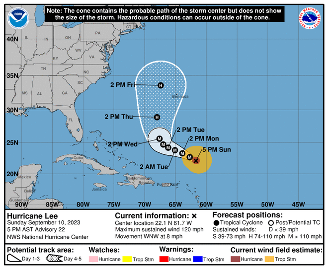
◾Lee was centered about 285 miles north-northeast of the Northern Leeward Islands Sunday at 5 p.m., heading north-northwest at 8 mph. Lee was driving sustained winds of 120 mph, a Category 3 storm.
◾No coastal watches or warnings were in effect, and forecasts say it won't make landfall.
◾The forecast calls for steady strengthening during the day or two before some gradualweakening, the hurricane center said.

Fast and furious: Lee grew to Cat 5 monster in a day
Last week, Lee set off alarm bells when it strengthened from Category 1 to Category 5 within 24 hours. A direct hit on the East Coast could have triggered catastrophe, and FEMA began sending supplies to Puerto Rico. But the threat was never realized.
And Lee wasn't the fastest Atlantic storm to intensify so severely. In October 2005, Wilma grew from a tropical storm to Category 5 hurricane status in 24 hours, the hurricane center says.
Hurricane Lee tracker
The forecast track cone shows the most likely path of the center of the storm, not the full width of the storm or its impacts. The center of the storm is likely to travel outside the cone up to 33% of the time.
Contributing: The Associated Press
Disclaimer: The copyright of this article belongs to the original author. Reposting this article is solely for the purpose of information dissemination and does not constitute any investment advice. If there is any infringement, please contact us immediately. We will make corrections or deletions as necessary. Thank you.


