Hurricane forecasters expect tropical cyclone to hit swath of East Coast with wind, rain
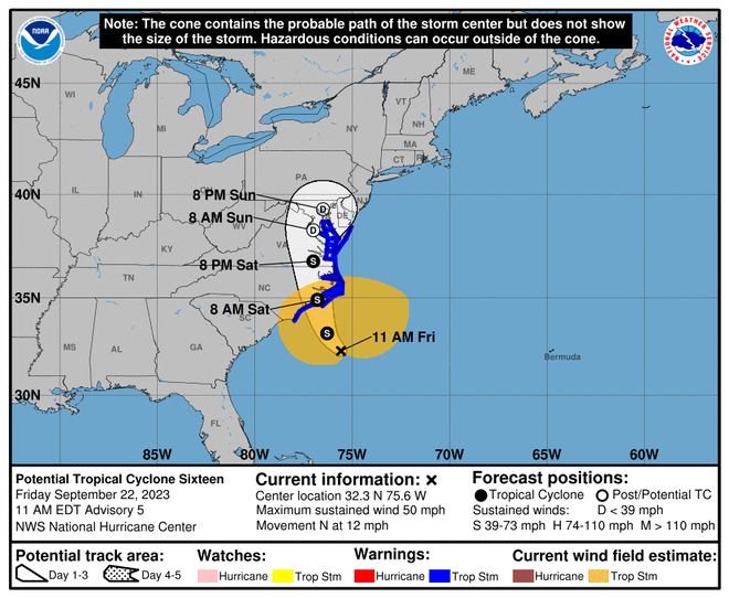
Tropical storm conditions are expected to begin Friday along portions of the East Coast, as a low pressure system in the Atlantic Ocean strengthens and is anticipated to become a tropical storm.
According to the National Hurricane Center, tropical storm conditions will first begin in North Carolina Friday morning and spread north Saturday. There is a danger of life-threatening storm surge in coastal areas, and high surf and rip currents also are expected through the weekend, along with heavy rainfall across the Mid-Atlantic, from North Carolina to New Jersey.
The system is likely to bring several inches of rain, according to the hurricane center, impacting outdoor events and NFL games.
According to a Friday morning update, the National Hurricane Center said the low pressure system is about 200 miles south of Cape Hatteras, North Carolina, with maximum sustained winds of 50 mph.
Those wind speeds are high enough for the system to be classified as a tropical storm, but forecasters say the system has not developed other characteristics of a tropical cyclone yet.
The hurricane center said landfall is expected in North Carolina around Saturday morning.

NWS warns of 'life-threatening' storm surge, rip currents
According to its Friday morning forecast, the hurricane center said dangerous rip currents and storm surge are expected along stretches of North Carolina and Virginia. Some coastal towns could see "life-threatening" storm surge up to five feet.
"Persons located within these areas should take all necessary actions to protect life and property from rising water and the potential for other dangerous conditions," the agency said. "Promptly follow evacuation and other instructions from local officials."
What's the difference between tropical cyclone and a tropical storm?
In the Atlantic Ocean, tropical depressions, tropical storms and hurricanes are all types of tropical cyclones.
That's because "tropical cyclone" is a generic term for the low pressure systems that form over warm tropical seas with a warm core, closed center of circulation and organized thunderstorm activity.
Here's how different types of tropical cyclones are defined:
- Tropical depression: maximum sustained surface winds of 38 mph
- Tropical storm: sustained surface winds of 39 mph to 73 mph. At this intensity, a storm is named.
- Hurricane: A tropical storm that has reached maximum sustained winds of 74 mph.
Could the storm become Ophelia?
If the strengthening low pressure system becomes a tropical or subtropical storm, as forecasters expect, it will be named Ophelia. It would be the 16th named storm of the 2023 Atlantic hurricane season, according to Colorado State University hurricane researcher Phil Klotzbach.

Contributing: Doyle Rice, USA TODAY; Kimberly Miller, Palm Beach Post; Pacific Daily News
Disclaimer: The copyright of this article belongs to the original author. Reposting this article is solely for the purpose of information dissemination and does not constitute any investment advice. If there is any infringement, please contact us immediately. We will make corrections or deletions as necessary. Thank you.


