Flooding continues across Northeast; thousands still without power: Live updates
Areas across New Jersey and through New England remained flooded on Tuesday as hundreds of thousands of people were without power a day after a storm ravaged much of the Northeast.
Many school districts canceled classes on Tuesday after the winter storm, which first blasted through the Midwest and Southeast, brought torrential rainfall and fierce winds to the region.
Flood warnings were in effect throughout the Northeast as entire roads remained under water often because of river runoff. The Androscoggin River, which flows through northeastern New Hampshire and southern Maine, was recorded at 22 feet on Tuesday morning – 7 feet above its flood stage. “At 20.6 feet, this is a 100-year flood,” the National Weather Service said.
The powerful storm system snarled traffic, delayed flights, toppled trees, knocked out power for hundreds of thousands and killed at least five people.
Wind gusts of up to 70 mph were recorded along the southern New England shoreline, according to the National Weather Service. More than 5 inches of rain fell in parts of New Jersey and northeastern Pennsylvania, and parts of several other states recorded more than 4 inches. About 471,700 utility customers were without power in Maine and Massachusetts as of Tuesday afternoon, according to PowerOutage.us.
Two men, one in Massachusetts and the other in Maine, were killed on Monday by fallen trees. A driver in Catskill, New York, was killed after the vehicle went around a barricade on a flooded road and was swept into the Catskill Creek, the Times Union reported. Authorities in Lancaster County, Pennsylvania, pronounced a man dead after he was discovered in a submerged vehicle Monday morning. And on Sunday, one person died when their vehicle flooded on a road in Mount Pleasant, South Carolina, according to WCBD.
Power outage maps:Over 500,000 customers without power in Maine, Massachusetts
'I couldn't sleep': Floods force residents to evacuate
Mathieu St. Thomas, 34, and his roommate were evacuated Tuesday from their mobile home in Fairfield, Maine, amid a flood that's worsened throughout the day as the Kennebec River continued to rise.
Thomas fled with his German Shepard, July, and his 10-year-old cat, Ruby, to the office where he works as a manager for a shipping and auditing firm. Throughout the day he's watched the news and the weather channel to find out when the water is expected to recede and when he can go back home, though he's nervous about the damage.
"I couldn't sleep all last night because of the storm. Our power was out the whole day," he told USA TODAY, adding that once at the office, he "almost cried" because he "never expected it to get this bad."
The Kennebec River was measured 13 feet above its flood stage on Tuesday afternoon, according to the National Weather Service. It's expected to rise at least another foot before receding Tuesday evening and into Wednesday.
Lance Chapman, 56, said the storm was most intense around 2 p.m. Monday, about the time he walked to Cushnoc Brewing Co. in downtown Augusta, Maine, where he works as a dishwasher.
“It was crazy,” he told USA TODAY. “I saw those trees slanted … and the wind, at times, sounded like freight train.”
Shingles were blown off his apartment, debris was strewn over cars and sidewalks and entire panels of his neighbor's fence were ripped out of the ground. He said water began to make its way into the shop's basement on Tuesday, ahead of high tide and the anticipated rise of the Kennebec River.
"We haven't seen anything like this," Chapman said of the sudden storm and heavy rainfall in the middle of December, a time in which his main weather concern is snow.
Heavy, lake-effect snow falls across interior Northeast
A stream of cold air bringing lake-effect snow to the interior Northeast on Tuesday brought dangerous travel conditions to the region, much of which was plagued by heavy rain a day earlier.
Parts of western New York, Pennsylvania and West Virginia were forecast to receive 10 to 12 inches of snow and wind gusts reaching speeds of 40 mph by Tuesday evening, according to the National Weather Service.
The conditions may trigger snow squalls, fast-moving storms that can drop temperatures and cause white-out conditions, making road travel "treacherous and potentially life-threatening," the National Weather Service said. Meteorologists warned people in the interior Northeast to "delay all travel if possible."
"A burst of very cold air will surge across the Great Lakes, Ohio Valley and Northeast ... will lead to one of winter's greatest dangers for highway motorists across the region," AccuWeather Meteorologist Jake Sojda said on Monday. "A few of the hardest-hit areas south of Buffalo, New York, and in the mountains of West Virginia could pick up snow totals in the double digits."

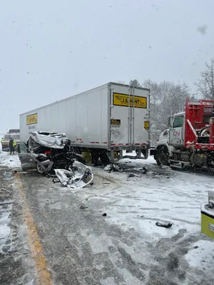
Snow storm to blame for pile-up in Michigan
Multiple people were injured in southwestern Michigan on Monday afternoon after multiple vehicles, including semi-trucks, crashed during a snow squall.
The highway pileup came as snowy weather conditions hit Michigan Monday, including lake-effect snow along west Michigan, according to the National Weather Service. Dropping temperatures and high wind combined with heavy and blowing snow pose hazardous road conditions in the area, including extremely low visibility.
Contributing: Doyle Rice, USA TODAY; Jenna Prestininzi, Detroit Free Press
Christopher Cann is a breaking news reporter for USA TODAY. Reach him via email at ccann@usatoday.com or follow him on X @ChrisCannFL.
Disclaimer: The copyright of this article belongs to the original author. Reposting this article is solely for the purpose of information dissemination and does not constitute any investment advice. If there is any infringement, please contact us immediately. We will make corrections or deletions as necessary. Thank you.


