Less snow, same blizzards? Climate change could have weird effects on snowfall in US.
Will climate change mean fewer big snowstorms like the blizzards occurring on both coasts and across the country this week?
You might be surprised. Researchers studying how the warming climate is changing snowfall and snowpack are drawing new conclusions about the future of snow, and it’s a mixed bag. Some researchers find overall snowfall declining in many areas, leaving less snow packed into mountain ranges in the spring, while others say the warmer winters won't prevent some of the more intense snow storms − at least not yet.
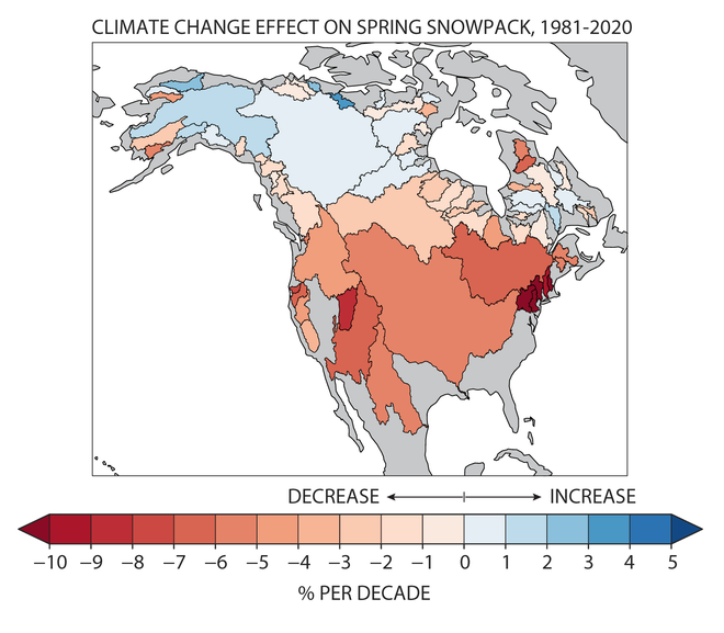
A new study by two Dartmouth College researchers looked at the decline of spring snowpack in major river basins in the Northern Hemisphere. They concluded the losses may be already be greater than anyone has realized, in part because it's such a challenging thing to measure. Their study, published Wednesday in the journal Nature, linked human-caused warming to declines in snowpack in at least 31 river basins in the hemisphere since 1981.
The researchers say their findings present “the most compelling evidence so far” that human greenhouse gas emissions have affected snowpack and crucial water resources in the southwestern and northeastern United States, as well as in Central and Eastern Europe.
The study is “a conservative estimate of the impacts of global warming on snow to date,” said senior author Justin Mankin, an associate professor of geography at the college. “If anything, I would expect that the impacts are considerably larger for many places. We are systematically underestimating the impact of global warming, in particular its impact on snow.”
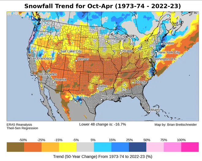
Meanwhile, a study of snowfall in the eastern U.S and Canada published in June found snowfall is changing, but not uniformly. Snowfall totals have declined in some areas and are expected to decline further, but they have increased in other areas, many of them clustered along the coast.
The most extreme daily snowfalls, however – like the ones seen last weekend in New England – are likely to continue, even in a warming climate, at least as long as it’s cold enough to snow, the study found.
Warmer air produces more moisture, so if the air is warmer – but still cold enough to snow – more snow is available to fall in extreme events, the scientists told USA TODAY. That study also found a bigger percentage of annual snowfall along the U.S.-Canada border is likely in fewer but larger events.
Study finds less spring snow sitting on the ground in the US
Snowpack and snowmelt supply crucial water resources to communities, farms and ecosystems in river basins around the world.
Mankin and Alexander Gottlieb, a doctoral candidate at Dartmouth, were drawn to their study by the challenges of measuring the water content in snowpack and because of the serious implications of the loss of water resources.
Though climate scientists have improved ways to measure sea level, rainfall, drought and other weather and climate patterns, accurate measurements for snowpack and its water content have remained elusive. Gottlieb said the use of satellites to measure snow cover has improved, but it’s still “tricky” to get the actual volume of the mass of snow on the ground.

Ultimately, the researchers combined historical observations of snow mass with snow cover records and climate models to predict how human-induced climate change could affect snow.
Jouni Pulliaine, a research professor at the Finnish Meteorological Institute whose analysis of the study’s methods was also published in Nature on Wednesday, said the pair had produced “a promising approach.”
The researchers documented spring snowpack loss, but there haven't yet been widespread losses, Mankin said. That is likely because the majority of snow in the Northern Hemisphere accumulates in places that are still so cold that several degrees of global warming haven't been enough to melt it, he said. But snowpack becomes more sensitive to warming when winter temperatures reach above minus 8 degrees Celsius, he said.
That means sharper declines are likely in the future, he said. “Once you move into this regime of accelerating snow loss, the trend is just going to tend to be downward.”

That could cause cascading troubles for downstream communities and the infrastructure established around expectations of runoff from snowmelt.
Intense snowstorms aren't going away anytime soon as Earth warms
Even though warming is forecast to decrease annual snowfall across much of eastern North America, co-authors of the June study said significant snow storms will still occur.
“We know that as the planet warms, we’re expecting more precipitation in general in the northeastern U.S. and southeastern Canada,” said lead author Christopher McCray. “But then in the winter, because it’s getting warmer, we’re expecting less and less snowfall overall.”
But the extremes are changing differently from the averages, said McCray, a scientist for Orono, a climate services group that works with the government of Quebec.
The top 5% of snowfall events, the largest and most intense, such as howling Nor’easters that blow into Boston with loads of snow, will continue. Even with 4 degrees of warming, McCray said, “you’re still seeing snowstorms that are like the most intense snowstorms.”
“In general, we’re going to have less snowfall, but we’re going to be losing more of the smaller snowfall events and keeping a lot of the bigger snowfall events,” McCray said. “In some places, they might occur less frequently, but they’re not going to disappear.”
In northern New England, upstate New York and southern Canada, that means more days where a large percentage of snow falls on a single day and fewer snowfall days in general, he said.
So far, parts of the Northeast seem to be bucking the trend toward decreasing snowfall in a warming world, said Brian Brettschneider, a study co-author and a climate scientist in Alaska. “But you are on borrowed time."
"In theory, if all the ingredients come together for a snowstorm, warmer air can hold more moisture, and you can squeeze out more snow,” he said. “As Boston keeps warming up and warming up, it’s just going to be less cold air to create snow.”
But other regional patterns could be at play, he said. For example, there’s uncertainty about whether climate change might favor storm tracks in the Northeast that produce more snow.
In the Great Lakes region, some areas are seeing less snow while others are seeing more snow, said Bryan Mroczka, a meteorologist with NOAA's Great Lakes Environmental Research Laboratory.
Warmer temperatures and delayed development of lake ice mean extended seasons with the potential for lake effect snow nearshore, Mroczka said. But areas further inland see less snow during warmer winters.
In Anchorage, Alaska, snowfall between December and February has increased 20% over the past 50 years, Brettschneider said. But the snow season has compressed, with less snow in October, November, March and April.

Disclaimer: The copyright of this article belongs to the original author. Reposting this article is solely for the purpose of information dissemination and does not constitute any investment advice. If there is any infringement, please contact us immediately. We will make corrections or deletions as necessary. Thank you.


