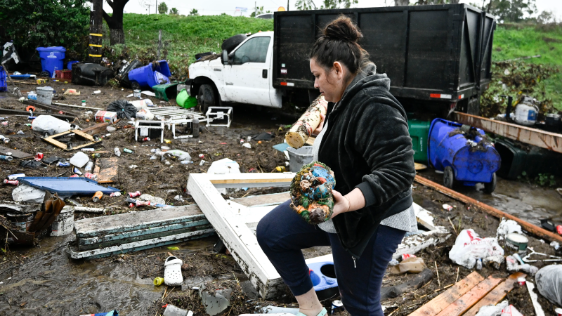
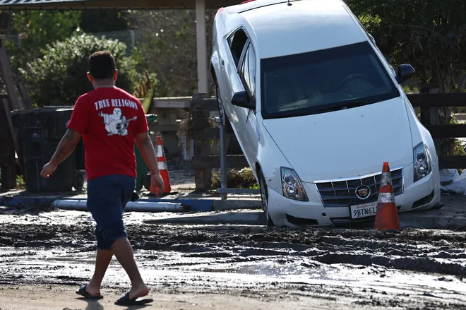
Dry, sunny San Diego was hit with damaging floods. What's going on? Is it climate change?
For the second time in a month, torrential flooding returned to Southern California this week with El NIño-fueled rains rolling in off the Pacific Ocean.
This time San Diego felt the punch. The city, known for weather "the closest thing to perfect in America," experienced one of its wettest days on record. California Governor Gavin Newsom and Mayor Todd Gloria issued emergency declarations after heavy rainfall created raging rivers, stranding motorists and washing away cars.
Such downpours are occurring more often across the country as the warming climate and oceans allow the atmosphere to hold more moisture, climate scientists say. And it's a phenomenon they expect to continue in the years to come. Couple that with the warmer than normal — and higher than normal — waters El Niño brings to the California coast, and it can be a recipe for disaster.

What happened in San Diego this week? Where did all the rain come from?
An atmospheric river brought in this week's plume of moisture, causing the record rain and flooding. These rivers in the sky can stretch for hundreds of miles, ferrying moist air from the tropics northeastward.
This atmospheric river happened to move right over a large pool of water to the west with temperatures 5.4 degrees warmer than normal, and one pocket of water roughly 7.5 degrees above normal, said Martin Ralph, director of the Center for Western Weather and Water Extremes at the Scripps Institution of Oceanography.
That "contributed substantially to the production of heavy rain," by supercharging the moisture and heat in the atmospheric river, Ralph said. A similar storm event happened in Santa Barbara during an El Nino in 1998, but water temperatures then were only about 3.6 degrees above normal.
Monday was San Diego's wettest January day on record and the 2.73 inches of rain at San Diego International Airport was the fourth wettest day in 174 years, the weather service said. Locations in the hills and mountains to the east of San Diego reported up to 5 inches of rain over 72 hours.
Other areas have also been hit by damaging floods recently
In December, Ventura County felt the brunt of the rain, as firefighters rescued people from the water and a senior-living community was evacuated in Port Hueneme. Rain rates at one point in that storm reached more than 3 inches per hour.
Both events are just the latest in a string of increasingly heavy rain storms climate scientists are attributing in part to the warming climate around the country.
The same system that dumped heavy rain on San Diego Monday helped fuel the storms that brought rain and floods to the South on Tuesday and Wednesday, National Weather Service meteorologist Marc Chenard told USA TODAY.
Similar heavy rain events happened in 2023 in Fort Lauderdale, Florida and Vermont.
It's not just happening in the U.S. John Dickson, president and CEO of the private flood insurance provider, Aon Edge, said this week that 70% of the catastrophes worldwide over the past 10 weeks had some element of flooding.
"It's the most devastating natural catastrophe globally, not just locally," Dickson said, and it's being driven by record-breaking rainfall and coastal flooding.
What's the short-term forecast for the Pacific Coast?
So far, the models are inconsistent, said Alex Tardy, warning coordination meteorologist for the weather service in San Diego.
"There's some indications of very active Pacific jet stream weather in early February," Tardy said. The weather service already has warned that it's going to be wetter than usual, but the details about which area of the coast could see the worst impacts aren't yet known.
California faces mounting flooding risks
Southern California also experienced flooding last August, when Hurricane Hilary brought record-breaking rainfall to the region, after appearing at one point to be poised for a rare Southern California landfall.
The San Diego Regional Climate Collaborative and others have warned these extreme rainfall events would be more likely as temperatures continue to rise, even in the midst of longer, more extreme drought periods.

Long-term climate studies show the region will see fewer days with moderate rainfall, while the top 1% of wettest days are going to become "much wetter," Ralph said. "Longer dry spells in between bigger, wetter events."
And those "events" are atmospheric rivers, he said. Climate studies show a 20% increase in the role of atmospheric rivers in the annual precipitation in locations along the Pacific Coast, he said. Atmospheric rivers already produce 30-50% of the annual precipitation, but are "going to produce more rain as time goes by."
Scientists have previously warned of the potential for a mega-flood in California as the climate warms.
How much of a role is El Niño playing?
Scientists are still trying to learn more about atmospheric rivers and to untangle any correlation between the El Niño / La Niña oscillation and how it affects rainfall on the Pacific coast, Ralph and others said during a Scripps briefing on Tuesday. Atmospheric rivers occur during both phases of the oscillation.
Scripps has been working with the National Oceanic and Atmospheric Administration and the U.S. Air Force Reserve this winter to conduct exploratory flights in the Pacific, flying out of Hawaii, to try to unravel some of those complicated questions, Ralph said. "We’re trying to make forecasts of atmospheric rivers better."
El Niño occurs when warmer-than-normal waters along the equator west of South America push west and trade winds weaken, and the atmosphere reacts to that changing wind pattern. The warm water is distributed north and south in the Pacific, and typically brings wetter-than-normal conditions in California.
El Niño also has helped generate large and powerful surf, like the massive waves at the Ventura coast in late December. It also pushes sea levels higher along the coast. So far, this winter the sea level is about four inches higher and growing, said Dan Rudnick, a professor of physical oceanography at Scripps.
The coastal impacts of higher seas and big waves are expected to grow with time, as the overall sea levels rise and the land sinks in some coastal locations. Sea levels at San Diego have risen about six inches over the past 100 years. By 2050, California sea levels are expected to rise between .5 and 1.2 feet, according to a recently released draft of the California Sea Level Rise report.
Disclaimer: The copyright of this article belongs to the original author. Reposting this article is solely for the purpose of information dissemination and does not constitute any investment advice. If there is any infringement, please contact us immediately. We will make corrections or deletions as necessary. Thank you.


