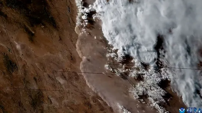
'Unbelievable': Video shows massive dust storm rolling across New Mexico

All eyes were on New Mexico Wednesday as a unique weather event swept through the region, enveloping many cities across the state in a thick brown haze momentarily.
The dust storm, also known as a "haboob" hit New Mexico and northern Mexico, carving 200-mile path through the area in seconds, according to satellite video footage obtained by USA TODAY.
Scientists in the area were more surprised by the haboob's size than by its pace, with a couple revealing on social media that it was the "largest" dust storm they had ever witnessed.
The haboob was generated by winds pushed forward, away from a major thunderstorm outbreak that began in central New Mexico, an area that has been devastated by wildfires in the last week, according to reporting by The Washington Post. The dust made its way over Arizona on Thursday morning, producing hazy skies in Phoenix, according to the National Weather Service.
Heavy rain and thunderstorms were also expected hit across New Mexico through Friday afternoon, USA TODAY reported. Areas that have been scorched by the fire were "particularly susceptible to debris flow and flash flooding concerns."
While the appearance of the haboob in New Mexico made for some pretty epic visuals, others were impacted by the gusts of winds and low visibility on the ground. Local news outlets reported that 18 people were sent to the hospital after a multi-car pileup on Interstate 25 near Algodones.
The weather event is known to create "hazardous conditions" for ground transportation systems, air traffic and motorists because high-speed winds can create a dusty and sandy wall as high as 10,000 feet, according to the National Oceanic and Atmospheric Administration. They can last "last for tens of minutes to a few hours," , according to the American Meteorological Society.
What's a haboob, anyway? Weather term defined
A haboob, derived from Arabic term "habb" which means to blow, was originally used to describe "wind or sandstorms" that occurred in central and northern Sudan, which averages about 24 a year, according to the American Meteorological Society.
Now, its typically used to describe "any" intense wind-driven sandstorm or dust storm that can loft sand or dust thousands of feet into the air, creating a visually stunning "wall of dust," according to the American Meteorological Society.
Haboobs occur when air is forced down and pushed forward by traveling thunderstorm cell, dragging dust and debris with it, according to the National Oceanic and Atmospheric Administration.
Haboobs have been seen in the Middle East, Arabian Peninsula, the Sahara Desert, and central Australia. In the U.S., haboobs are typically observed in regions in the Southwest, from the Sonoran Desert of northwest Mexico and Arizona to the western portions of the Great Plains," The American Meteorological Society states.
Watch: Haboob sweeps across entire regions in seconds
Many were stoked to see a haboob in real life, taking to social media to share reactions and images of the dust storm from their POV.
"Largest haboob I've observed in 20 years or perhaps longer in the Chihuahuan Desert is propagating from east to west. Extends hundreds of kilometers from central New Mexico well into Chihuahua," Tom Gill, a professor at The University of Texas at El Paso wrote on X.
Daniel Swain, a climate scientist, echoed a similar sentiment in the comments under Gill's post, writing: "I had the same reaction to the satellite imagery this evening...I also think this is among (if not the) largest haboob I've seen in the Southwest!"
Others called the satellite imagery "unbelievable" and "incredible," sharing pictures and footage of the haboob as it made its way through.
Disclaimer: The copyright of this article belongs to the original author. Reposting this article is solely for the purpose of information dissemination and does not constitute any investment advice. If there is any infringement, please contact us immediately. We will make corrections or deletions as necessary. Thank you.


